Welcome to Visit Gatley Places
The Walkfo guide to things to do & explore in Gatley
 Visit Gatley places using Walkfo for free guided tours of the best Gatley places to visit. A unique way to experience Gatley’s places, Walkfo allows you to explore Gatley as you would a museum or art gallery with audio guides.
Visiting Gatley Walkfo Preview
When you visit Gatley, Walkfo brings Gatley places to life as you travel by foot, bike, bus or car with a mobile phone & headphones.
Gatley Places Overview: History, Culture & Facts about Gatley
Visit Gatley – Walkfo’s stats for the places to visit
With 90 audio plaques & Gatley places for you to explore in the Gatley area, Walkfo is the world’s largest heritage & history digital plaque provider. The AI continually learns & refines facts about the best Gatley places to visit from travel & tourism authorities (like Wikipedia), converting history into an interactive audio experience.
Gatley history
Toponymy
In 1290, Gatley was known as Gateclyve, which in Middle English means “a place where goats are kept” within the boundaries of the historic county of Cheshire .
Early history
Until the 20th century, most Gatley residents either worked in the material trades or were farmers . An open field system existed around Gatley in the late 17th century . The practice of common farming fell into disuse when William Tatton allowed tenants to buy own land .
Industrial history

Button making appears to have been a significant local trade in the 17th and 18th centuries . A “button man” (merchant selling buttons) is recorded in Gatley in the 1660s . This continued in the 18th century with three button men mentioned between 1735 and 1779 .
Halls and houses
Stone Pale Hall was reconstructed in 1714 in Gatley, Gatley . In 1714, it was re-built in the same place in 1715 . It is now located in London .
Conflict
Wythenshawe Hall was kept in a state of defence from 1642, with Parliamentary forces nearby in Handforth and Duckinfield . The Tatton family, along with the local rectors and most tenants, were Royalists .
Religion and churches
A nonconformist meeting house registered in Etchells in 1722 may have been a house in Gatley . Gatley Congregational Church was founded and an independent chapel was built in Old Hall Road, Gatley, following the spread of evangelicalism .
Site of Gatley Medical Centre
Gatley Medical Centre on Old Hall Road has previously been the location for a variety of purposes over the centuries . The site currently occupied by the medical centre has been the site of a number of medical facilities over the years .
Gatley culture & places
Gatley Festival
Gatley Festival is an annual summer event held on the first Sunday in July each year . It is a celebration of village life and includes a carnival parade and family fun day .
Gatley Music Festival
Gatley Music Festival runs in March for one week each year . It has its roots in “Music at St James”, set up in 1989 by the Rev. Brian Lee and Len Mather .
Gatley geography / climate
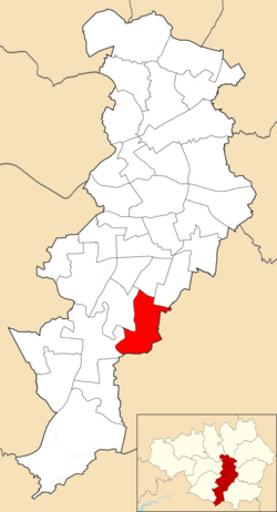
Gatley is the most westerly vicinity of the Metropolitan Borough of Stockport. Until 1974 it was within Cheshire as a suburban township of Cheadle. It is approximately 3 miles (5 km) due northeast of Manchester Airport.
Why visit Gatley with Walkfo Travel Guide App?
 You can visit Gatley places with Walkfo Gatley to hear history at Gatley’s places whilst walking around using the free digital tour app. Walkfo Gatley has 90 places to visit in our interactive Gatley map, with amazing history, culture & travel facts you can explore the same way you would at a museum or art gallery with information audio headset. With Walkfo, you can travel by foot, bike or bus throughout Gatley, being in the moment, without digital distraction or limits to a specific walking route. Our historic audio walks, National Trust interactive audio experiences, digital tour guides for English Heritage locations are available at Gatley places, with a AI tour guide to help you get the best from a visit to Gatley & the surrounding areas.
“Curated content for millions of locations across the UK, with 90 audio facts unique to Gatley places in an interactive Gatley map you can explore.”
Walkfo: Visit Gatley Places Map
90 tourist, history, culture & geography spots
Gatley historic spots | Gatley tourist destinations | Gatley plaques | Gatley geographic features |
| Walkfo Gatley tourism map key: places to see & visit like National Trust sites, Blue Plaques, English Heritage locations & top tourist destinations in Gatley | |||
Best Gatley places to visit
Gatley has places to explore by foot, bike or bus. Below are a selection of the varied Gatley’s destinations you can visit with additional content available at the Walkfo Gatley’s information audio spots:
 | Cheadle Heath Nomads F.C. Cheadle Heath Nomads Football Club was formed in 2004–05 season from a merger of two local clubs. They are currently members of the North West Counties League Division One South and play at the Proseal Stadium. |
 | Park Road Stadium Park Road Stadium is the home ground of North West Counties Football League club Cheadle Town F.C. It has a capacity of 2,000 people, with 100 seated. |
 | Heaton Mersey Heaton Mersey is a mostly residential area and commuter zone for Manchester. It is situated on the north-western border of Stockport, adjacent to Didsbury and Burnage in Manchester. Heaton Norris, Heaton Chapel and Heaton Moor are collectively known as the Four Heatons. |
 | Parrs Wood Parrs Wood is an area of East Didsbury, in south Manchester, England. It was formerly the estate surrounding Parrrs Wood House, an 18th-century Georgian villa. Today the area incorporates part of Wilmslow Road and is home to a Tesco supermarket. |
 | Wythenshawe Park Wythenshawe Park is a Green Flag awarded park covering 270 acres. The park features woodland, bedding, grassland and meadows, sporting facilities, a community farm and a horticulture centre. |
 | Northern Moor Northern Moor is west of Northenden and east of Sale, 5 miles south of Manchester city centre. The Tatton family lived at from 1540 to 1926 Wythenshawe Hall, which is in Northern Moor. Until the early 1900s Northern Moor was part of Cheshire, before Manchester expanded south of the River Mersey. |
 | Wythenshawe Town F.C. Wythenshawe Town Football Club is a football club based in Manchester. They are currently members of the North West Counties League Premier Division and play at Ericstan Stadium. |
 | Didsbury East (ward) Didsbury East is an area and electoral ward of Manchester. It is represented in Westminster by Jeff Smith MP for Manchester Withington. The 2011 Census recorded a population of 14,333. |
 | St Paul’s Methodist Church, Didsbury St Paul’s Methodist Church is a former Methodist church in Didsbury, Manchester. The building was designed by the architect H.H. Vale as a church for the nearby Wesleyan Theological Institution and opened in 1877. It is recorded in the National Heritage List as a designated Grade II listed building. |
 | Didsbury West (ward) Didsbury West is a suburb and electoral ward of Manchester. It is represented in Westminster by Jeff Smith MP for Manchester Withington. The 2011 Census recorded a population of 12,455. |
Visit Gatley plaques
 11
11
plaques
here Gatley has 11 physical plaques in tourist plaque schemes for you to explore via Walkfo Gatley plaques audio map when visiting. Plaques like National Heritage’s “Blue Plaques” provide visual geo-markers to highlight points-of-interest at the places where they happened – and Walkfo’s AI has researched additional, deeper content when you visit Gatley using the app. Experience the history of a location when Walkfo local tourist guide app triggers audio close to each Gatley plaque. Explore Plaques & History has a complete list of Hartlepool’s plaques & Hartlepool history plaque map.


 Trying to encourage visitors to Gatley?