Welcome to Visit Cwmdare Places The Walkfo guide to things to do & explore in Cwmdare
Visit Cwmdare places using Walkfo for free guided tours of the best Cwmdare places to visit. A unique way to experience Cwmdare’s places, Walkfo allows you to explore Cwmdare as you would a museum or art gallery with audio guides.
Visiting Cwmdare Walkfo Preview When you visit Cwmdare, Walkfo brings Cwmdare places to life as you travel by foot, bike, bus or car with a mobile phone & headphones.
Cwmdare Places Overview: History, Culture & Facts about Cwmdare
Visit Cwmdare – Walkfo’s stats for the places to visit
With 52 audio plaques & Cwmdare places for you to explore in the Cwmdare area, Walkfo is the world’s largest heritage & history digital plaque provider. The AI continually learns & refines facts about the best Cwmdare places to visit from travel & tourism authorities (like Wikipedia), converting history into an interactive audio experience.
Cwmdare history
Before the exploitation of the South Wales Coalfield, Cwmdare was a scattering of a few houses and farms. In the 1850s with the Industrial Revolution fuelling the demand for coal, several deep coal mines were constructed in the area.
Why visit Cwmdare with Walkfo Travel Guide App?
You can visit Cwmdare places with Walkfo Cwmdare to hear history at Cwmdare’s places whilst walking around using the free digital tour app. Walkfo Cwmdare has 52 places to visit in our interactive Cwmdare map, with amazing history, culture & travel facts you can explore the same way you would at a museum or art gallery with information audio headset. With Walkfo, you can travel by foot, bike or bus throughout Cwmdare, being in the moment, without digital distraction or limits to a specific walking route. Our historic audio walks, National Trust interactive audio experiences, digital tour guides for English Heritage locations are available at Cwmdare places, with a AI tour guide to help you get the best from a visit to Cwmdare & the surrounding areas.
“Curated content for millions of locations across the UK, with 52 audio facts unique to Cwmdare places in an interactive Cwmdare map you can explore.”
Walkfo Cwmdare tourism map key: places to see & visit like National Trust sites, Blue Plaques, English Heritage locations & top tourist destinations in Cwmdare
Best Cwmdare places to visit
Cwmdare has places to explore by foot, bike or bus. Below are a selection of the varied Cwmdare’s destinations you can visit with additional content available at the Walkfo Cwmdare’s information audio spots:
St Fagan’s Church, Trecynon St Fagan’s Church is a Grade II-listed Anglican church in the village of Trecynon near Aberdare, Rhondda Cynon Taf, Wales . It was originally built in the mid-nineteenth century in the Gothic Revival style .
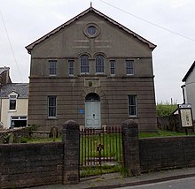
Hen-Dy-Cwrdd Hen-Dy-Cwrdd is a disused Unitarian chapel in Trecynon, Aberdare, Wales . Services at the chapel were conducted in the Welsh language .
Elim, Cwmdare Elim, Cwmdare was an Independent (Congregationalist) chapel in Aberdare, Wales . The chapel was built in the 1920s and 1930s .
Salem, Robertstown Salem, Robertstown is an Independent (Congregationalist) chapel in Robertstown, Aberdare, Wales. The chapel is located in Bridge Street, Robertstown.
St John’s Church, Aberdare St John the Baptist’s is an ancient parish church in Aberdare, Wales. It is located in the centre of the town of Aberdares.
Siloa, Aberdare Siloa was the largest of the Welsh Independent, or Congregationalist, chapels in Aberdare. Established in 1844, Siloa is one of the few Welsh language chapels to remain open today.
St Elvan’s Church, Aberdare St Elvan’s Church is a Grade II* listed Anglican church. It was built in 1851–1852, largely at the instigation of John Griffith, vicar of Aberdare from 1847 until 1859. The population of the parish was close to 14,000 people and increasing at a rate of approximately a thousand each year.
Aberdare General Hospital Aberdare General Hospital (Welsh: Ysbyty Cyffredinol Aberdâr) was a health facility in Rhondda Cynon Taf. It was managed by the Cwm Taf Morgannwg University Health Board.
Saron, Aberaman Saron, Aberaman was a Welsh Independent (Congregationalist) chapel in Aberaman. It was formed as an initiative of David Price of Siloa, Aberdare. Saron was claimed to be the largest chapel in the Cynon Valley.
Bethania, Cwmbach Bethania, Cwmbach was a Baptist Chapel in the Aberdare Valley in Wales. Badly damaged by an air raid attack in 1941 it was restored but closed in the 1980s. Services were held in the Welsh language.
Visit Cwmdare plaques
3 plaques hereCwmdare has 3 physical plaques in tourist plaque schemes for you to explore via Walkfo Cwmdare plaques audio map when visiting. Plaques like National Heritage’s “Blue Plaques” provide visual geo-markers to highlight points-of-interest at the places where they happened – and Walkfo’s AI has researched additional, deeper content when you visit Cwmdare using the app. Experience the history of a location when Walkfo local tourist guide app triggers audio close to each Cwmdare plaque. Explore Plaques & History has a complete list of Hartlepool’s plaques & Hartlepool history plaque map.
Experience Cwmdare audio walks & tours
Walkfo guides for things to do / places to visit in Cwmdare allows exploration as you would do an art gallery or museum. Walk close to one of Cwmdare’s 52 historic places & our digital tour guide will create an audio story for that spot. With headphone connected, you can explore Cwmdare freely by foot, bike or bus – with your own personal tour guide in your pocket.
Explore Cwmdare Map App
Our visit Cwmdare map shows you things-to-do & places you can visit in Cwmdare & surrounding areas using the Walkfo digital audio tour guide app. Each spot has plaque, building, street or area information on history, culture or tourism.
You can set your Walkfo’s Cwmdare tourist map to find historic & tourism spots within 1km, 3km & 5km of the Cwmdare centre, depending on how far you plan to explore whilst you visit Cwmdare area at LONG:-3.466667, LAT:51.716667.
Walkfo App
Walkfo
Walkfo is free to download & use (for a limited time period), so if you are looking to explore Cwmdare, go to your App Store to search for “Walkfo” or follow a links below and install on your mobile phone. Walkfo is designed for use with headphones or AirPods, so you can walk & explore whilst learning about the things around you without digital distraction.
Getting to / around Cwmdare – transport link, station & street map
Getting around in Cwmdare using public transportation may include road, street, train, underground, bus or tram transport options. Walkfo has identified the following Cwmdare places with historic / cultural / factual content when you visit:
Local Cwmdare Public Transport Stations
Cwmdare Notable Streets & Road Destinations
Aberdare railway station
Aberdare Low Level railway station
Abernant railway station
Aberaman railway station
Cwmbach railway station
Black Lion Crossing Halt railway station
[transportsummary]
Local Cwmdare historians & Cwmdare tour guides
Trying to encourage visitors to Cwmdare? Walkfo has millions audio places already available but Walkfo Creator gives Cwmdare’s places, attractions & landmarks ability to create their own unique outdoor audio museums & using our simple & easy to use Walkfo Creator. – Creating a new audio experience for your Cwmdare place is free* and quick (15+ minutes if you prepare text content) to use, with Walkfo Creator doing the hard work of generating AI audio files for geo-spots from the text you provide with a simply click on a map. – The 100 Amazing Cwmdare Places is just one example of an outdoor museum created using Walkfo Creator (pictured to the left) for people to safely explore during Covid-19 times whilst visiting a city. Our tool is open to tourism organisations, travel destinations & National Trust locations to create their own audio walks to offer free when people visit Cwmdare destinations. – Walkfo itself is looking to partner with websites offering things-to-do / what’s on events listings to enhance the content of our ‘visit-Cwmdare’ web pages (for example: www.visitCwmdare.com). If you are interested in partnering, please contact us to discuss options.
* Walkfo Creator is free to use for a limited number of audio spots within a map with a license fee applicable when more than 20 audio spots within location walk are created. v1.1336
 Visit Cwmdare places using Walkfo for free guided tours of the best Cwmdare places to visit. A unique way to experience Cwmdare’s places, Walkfo allows you to explore Cwmdare as you would a museum or art gallery with audio guides.
 You can visit Cwmdare places with Walkfo Cwmdare to hear history at Cwmdare’s places whilst walking around using the free digital tour app. Walkfo Cwmdare has 52 places to visit in our interactive Cwmdare map, with amazing history, culture & travel facts you can explore the same way you would at a museum or art gallery with information audio headset. With Walkfo, you can travel by foot, bike or bus throughout Cwmdare, being in the moment, without digital distraction or limits to a specific walking route. Our historic audio walks, National Trust interactive audio experiences, digital tour guides for English Heritage locations are available at Cwmdare places, with a AI tour guide to help you get the best from a visit to Cwmdare & the surrounding areas.


 3
3


 Trying to encourage visitors to Cwmdare?