Welcome to Visit Chorltonville Places
The Walkfo guide to things to do & explore in Chorltonville
 Visit Chorltonville places using Walkfo for free guided tours of the best Chorltonville places to visit. A unique way to experience Chorltonville’s places, Walkfo allows you to explore Chorltonville as you would a museum or art gallery with audio guides.
Visiting Chorltonville Walkfo Preview
When you visit Chorltonville, Walkfo brings Chorltonville places to life as you travel by foot, bike, bus or car with a mobile phone & headphones.
Chorltonville Places Overview: History, Culture & Facts about Chorltonville
Visit Chorltonville – Walkfo’s stats for the places to visit
With 120 audio plaques & Chorltonville places for you to explore in the Chorltonville area, Walkfo is the world’s largest heritage & history digital plaque provider. The AI continually learns & refines facts about the best Chorltonville places to visit from travel & tourism authorities (like Wikipedia), converting history into an interactive audio experience.
Chorltonville history
Chorltonville was conceived by two local businessmen, James Herbert Dawson and William John Vowles, and built between 1910 and 1911.
Chorltonville geography / climate

The Chorltonville estate comprises 262 houses in twelve roads, centred on a “village green” It measures about 550 yards east-west by 280 yards north-south—around 26 acres. The estate and an adjoining football field are one of Manchester Council’s 32 conservation areas.
Why visit Chorltonville with Walkfo Travel Guide App?
 You can visit Chorltonville places with Walkfo Chorltonville to hear history at Chorltonville’s places whilst walking around using the free digital tour app. Walkfo Chorltonville has 120 places to visit in our interactive Chorltonville map, with amazing history, culture & travel facts you can explore the same way you would at a museum or art gallery with information audio headset. With Walkfo, you can travel by foot, bike or bus throughout Chorltonville, being in the moment, without digital distraction or limits to a specific walking route. Our historic audio walks, National Trust interactive audio experiences, digital tour guides for English Heritage locations are available at Chorltonville places, with a AI tour guide to help you get the best from a visit to Chorltonville & the surrounding areas.
“Curated content for millions of locations across the UK, with 120 audio facts unique to Chorltonville places in an interactive Chorltonville map you can explore.”
Walkfo: Visit Chorltonville Places Map
120 tourist, history, culture & geography spots
Chorltonville historic spots | Chorltonville tourist destinations | Chorltonville plaques | Chorltonville geographic features |
| Walkfo Chorltonville tourism map key: places to see & visit like National Trust sites, Blue Plaques, English Heritage locations & top tourist destinations in Chorltonville | |||
Best Chorltonville places to visit
Chorltonville has places to explore by foot, bike or bus. Below are a selection of the varied Chorltonville’s destinations you can visit with additional content available at the Walkfo Chorltonville’s information audio spots:

Hough End Hall
Hough End Hall is a historic house now in Chorlton-cum-Hardy, (originally in Withington), Manchester . It was built in 1596 during the reign of Queen Elizabeth I by Sir Nicholas Mosley . The Mosleys were an influential Mancunian family from the 16th century onwards .

Chorlton Poor Law Union
Chorlton Poor Law Union was founded in January 1837 in response to the Poor Law Amendment Act 1834 . It was overseen by an elected board of 19 guardians representing the 12 parishes in the area it served .

Southern Cemetery, Manchester
Southern Cemetery is a large municipal cemetery in Chorlton-cum-Hardy, Manchester, England . It opened in 1879 and is owned and administered by Manchester City Council . It is the second largest cemetery in Europe and the largest in the UK .

St Ann’s, Stretford
St Ann’s Church, Stretford is a Grade II listed Roman Catholic church . It was constructed between 1862 and 1863, on the east side of the A56 Chester Road . The parish functions under the jurisdiction of the Roman Catholic Diocese of Salford .

Municipal Borough of Stretford
Stretford was, from 1868 to 1974, a local government district coterminate with the town of Stretford, Lancashire.
Municipal Borough of Sale
Sale was, from 1867 to 1974, a district in Cheshire. The district had the status of local government district, urban district and municipal borough. Its area now forms part of the Metropolitan Borough of Trafford.
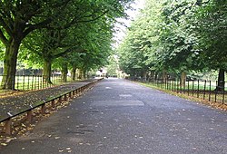
Wythenshawe Park
Wythenshawe Park is a Green Flag awarded park covering 270 acres. The park features woodland, bedding, grassland and meadows, sporting facilities, a community farm and a horticulture centre.

Northern Moor
Northern Moor is west of Northenden and east of Sale, 5 miles south of Manchester city centre. The Tatton family lived at from 1540 to 1926 Wythenshawe Hall, which is in Northern Moor. Until the early 1900s Northern Moor was part of Cheshire, before Manchester expanded south of the River Mersey.

Church of St John the Divine, Brooklands
The Church of St John the Divine is a Church of England parish church in Sale, Greater Manchester. The church is a grade II* listed building.

Brooklands (Manchester ward)
Brooklands is an area and electoral ward of Manchester. It is represented in Westminster by Mike Kane, MP for Wythenshawe and Sale East. The 2011 Census recorded a population of 14,362.
Visit Chorltonville plaques
 24
24
plaques
here Chorltonville has 24 physical plaques in tourist plaque schemes for you to explore via Walkfo Chorltonville plaques audio map when visiting. Plaques like National Heritage’s “Blue Plaques” provide visual geo-markers to highlight points-of-interest at the places where they happened – and Walkfo’s AI has researched additional, deeper content when you visit Chorltonville using the app. Experience the history of a location when Walkfo local tourist guide app triggers audio close to each Chorltonville plaque. Explore Plaques & History has a complete list of Hartlepool’s plaques & Hartlepool history plaque map.


 Trying to encourage visitors to Chorltonville?