Welcome to Visit Chorley Places
The Walkfo guide to things to do & explore in Chorley
 Visit Chorley places using Walkfo for free guided tours of the best Chorley places to visit. A unique way to experience Chorley’s places, Walkfo allows you to explore Chorley as you would a museum or art gallery with audio guides.
Visiting Chorley Walkfo Preview
Chorley is 8.1 miles (13 km) north of Wigan, 10.8 miles (17 km) south west of Blackburn, 11.8m north west of Bolton and 12m south of Preston. At the 2011 Census, it had a population of 34,667. The town’s wealth came principally from the cotton industry. When you visit Chorley, Walkfo brings Chorley places to life as you travel by foot, bike, bus or car with a mobile phone & headphones.
Chorley Places Overview: History, Culture & Facts about Chorley
Visit Chorley – Walkfo’s stats for the places to visit
With 42 audio plaques & Chorley places for you to explore in the Chorley area, Walkfo is the world’s largest heritage & history digital plaque provider. The AI continually learns & refines facts about the best Chorley places to visit from travel & tourism authorities (like Wikipedia), converting history into an interactive audio experience.
Chorley history
Toponymy
The name Chorley comes from two Anglo-Saxon words, ċeorl and lēah, probably meaning “the peasants’ clearing” Ley is a common element of place-name, meaning a clearing in a woodland.
Prehistory
There was no known occupation in Chorley until the Middle Ages. The area around the town has been inhabited since at least the Bronze Age. A pottery burial urn from this period was discovered in 1963 on land next to Astley Hall Farm.
Roman period
During the Roman era a Roman road ran near Chorley between Wigan and Walton-le-Dale. Hoards dating from the Roman period have also been found at nearby sites.
Medieval period
Chorley was not listed in the Domesday Book of 1086, though it is thought to be one of the twelve berewicks in the Leyland Hundred. It first appears in historical records in the mid thirteenth century as part of the Croston Lordship acquired by William de Ferrers, Earl of Derby, around 1250. The Earl established a small borough as a two-row settlement along what later became Market Street. It is most likely that the borough was sacked by the Scots during the Great Raid of 1322, which led to the construction of a Peel tower.
19th century to present
Chorley was a vital cotton town with many mills littering the skyline up to the late twentieth century. Most mills were demolished between the 1950s and 2000s with those remaining converted for modern business purposes. The last mill to stop producing textiles was Lawrence’s in 2009.
Chorley geography / climate

The name of the River Chor was back-formed from “Chorley” and runs not far from the centre of the town. Chorley is located at the foot of the West Pennine Moors. The principal river in the town is the Yarrow.
Why visit Chorley with Walkfo Travel Guide App?
 You can visit Chorley places with Walkfo Chorley to hear history at Chorley’s places whilst walking around using the free digital tour app. Walkfo Chorley has 42 places to visit in our interactive Chorley map, with amazing history, culture & travel facts you can explore the same way you would at a museum or art gallery with information audio headset. With Walkfo, you can travel by foot, bike or bus throughout Chorley, being in the moment, without digital distraction or limits to a specific walking route. Our historic audio walks, National Trust interactive audio experiences, digital tour guides for English Heritage locations are available at Chorley places, with a AI tour guide to help you get the best from a visit to Chorley & the surrounding areas.
“Curated content for millions of locations across the UK, with 42 audio facts unique to Chorley places in an interactive Chorley map you can explore.”
Walkfo: Visit Chorley Places Map
42 tourist, history, culture & geography spots
Chorley historic spots | Chorley tourist destinations | Chorley plaques | Chorley geographic features |
| Walkfo Chorley tourism map key: places to see & visit like National Trust sites, Blue Plaques, English Heritage locations & top tourist destinations in Chorley | |||
Best Chorley places to visit
Chorley has places to explore by foot, bike or bus. Below are a selection of the varied Chorley’s destinations you can visit with additional content available at the Walkfo Chorley’s information audio spots:
 | Charnock Richard F.C. Charnock Richard Football Club is a football club based near Chorley, Lancashire. They are currently members of the North West Counties League Premier Division and play at Mossie Park. |
 | Mavis Mill Mavis Mill was built in 1908 alongside the Coppull Ring Mill, which still survives under a change of use to an enterprise centre. The mill was taken over by the Lancashire Cotton Corporation in the 1930s, but was subsequently demolished to make a car park. |
 | Coppull Mill Coppull Mill is a former cotton spinning mill in Chorley, Lancashire. It was opened in 1906, and its sister mill, Mavis Mill in 1908. Together they employed 700 workers. The mill was taken over by the Lincashire Cotton Corporation in the 1930s and passed to Courtaulds in 1964. |
 | Buckshaw Hall Buckshaw Hall is a grade II* listed 17th-century country house in Buckshaw Village, Euxton, some 3 miles (4.8 km) north-west of Chorley, England. |
 | Euxton Parish Church Euxton Parish Church is an active parish church in the Diocese of Blackburn and the archdeaconry of Blackburn. It is recorded in the National Heritage List for England as a designated Grade II* listed building. |
 | Buckshaw Village Buckshaw Village is one of the largest urban development sites in the North West of England with a population of about 4,000. The new development is taking place on the former site of the Royal Ordnance Factory (ROF) Chorley, which was requisitioned by the War Office in the 1930s. |
 | Pestalozzi International Village Pestalozzi International Foundation is an educational charitable organisation based in East Sussex, England. The foundation is based in the East Sussex borough of East Sussex. |
 | Chorley and South Ribble Hospital The hospital is situated on Euxton lane in Chorley close to junction 8 of the M61. It is managed by Lancashire Teaching Hospitals NHS Foundation Trust. |
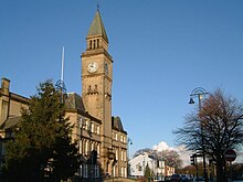
 | Chorley Town Hall Chorley Town Hall is a municipal building in Market Street in Chorly, Lancashire, England. It is located in the centre of Market Street. |
 | Municipal Borough of Chorley The Municipal Borough of Chorley was a local government district in the administrative county of Lancashire. It was coterminated with the town of Chorley. |
Visit Chorley plaques
 0
0
plaques
here Chorley has 0 physical plaques in tourist plaque schemes for you to explore via Walkfo Chorley plaques audio map when visiting. Plaques like National Heritage’s “Blue Plaques” provide visual geo-markers to highlight points-of-interest at the places where they happened – and Walkfo’s AI has researched additional, deeper content when you visit Chorley using the app. Experience the history of a location when Walkfo local tourist guide app triggers audio close to each Chorley plaque. Currently No Physical Plaques.


 Trying to encourage visitors to Chorley?