Welcome to Visit Charlwood Places
The Walkfo guide to things to do & explore in Charlwood
 Visit Charlwood places using Walkfo for free guided tours of the best Charlwood places to visit. A unique way to experience Charlwood’s places, Walkfo allows you to explore Charlwood as you would a museum or art gallery with audio guides.
Visiting Charlwood Walkfo Preview
Charlwood is a village and civil parish in the Mole Valley district of Surrey. It is immediately northwest of London Gatwick Airport in West Sussex, close west of Horley and north of Crawley. The historic county boundary between Surrey and Sussex ran to the south of Charlwood. When you visit Charlwood, Walkfo brings Charlwood places to life as you travel by foot, bike, bus or car with a mobile phone & headphones.
Charlwood Places Overview: History, Culture & Facts about Charlwood
Visit Charlwood – Walkfo’s stats for the places to visit
With 25 audio plaques & Charlwood places for you to explore in the Charlwood area, Walkfo is the world’s largest heritage & history digital plaque provider. The AI continually learns & refines facts about the best Charlwood places to visit from travel & tourism authorities (like Wikipedia), converting history into an interactive audio experience.
Charlwood history
Before 1800
Charlwood Place is a 16th-century listed moated house situated on the northwestern perimeter of the village. The mother of John Pitseus, a recusant Bishop in France, lived there. A historic cricket match was held in Charlwood in June 1741.
After 1800
Charlwood has more crown post timber-framed houses than any other village in Britain. Total enclosure (of the common land) took place in phases: in 1843, 1844 and 1854.
Charlwood landmarks
Lowfield Heath Windmill
Charlwood’s western limestone escarpment is the home of this windmill. It was moved from Lowfield Heath when it was threatened with demolition in the 1970s. Part of which took place to accommodate Gatwick Airport’s growth.
Church
St Nicholas’s is a Grade I listed building with intact Norman era stones. It has a particularly historically significant series of murals on the south wall of the chancel, contemporary with the south aisle which has been dated as c. 1300.
Providence Chapel
Providence Chapel was re-erected there in 1816 after being moved from Horsham, where it served as an officers’ mess during the Napoleonic Wars. It was used as a Nonconformist chapel for almost 200 years, but was put up for sale in 2012.
Charlwood geography / climate
A narrow ridge of Sussex Marble runs through the west of the parish, where it is followed for a distance by the Sussex Border Path. Elevations range from 60 to 140m above sea level and no dual carriageways bisect the area.
Why visit Charlwood with Walkfo Travel Guide App?
 You can visit Charlwood places with Walkfo Charlwood to hear history at Charlwood’s places whilst walking around using the free digital tour app. Walkfo Charlwood has 25 places to visit in our interactive Charlwood map, with amazing history, culture & travel facts you can explore the same way you would at a museum or art gallery with information audio headset. With Walkfo, you can travel by foot, bike or bus throughout Charlwood, being in the moment, without digital distraction or limits to a specific walking route. Our historic audio walks, National Trust interactive audio experiences, digital tour guides for English Heritage locations are available at Charlwood places, with a AI tour guide to help you get the best from a visit to Charlwood & the surrounding areas.
“Curated content for millions of locations across the UK, with 25 audio facts unique to Charlwood places in an interactive Charlwood map you can explore.”
Walkfo: Visit Charlwood Places Map
25 tourist, history, culture & geography spots
Charlwood historic spots | Charlwood tourist destinations | Charlwood plaques | Charlwood geographic features |
| Walkfo Charlwood tourism map key: places to see & visit like National Trust sites, Blue Plaques, English Heritage locations & top tourist destinations in Charlwood | |||
Best Charlwood places to visit
Charlwood has places to explore by foot, bike or bus. Below are a selection of the varied Charlwood’s destinations you can visit with additional content available at the Walkfo Charlwood’s information audio spots:
![]()
Horley Town F.C.
Horley Town Football Club is a football club based in Horley, Surrey. They are currently members of the Combined Counties League Premier Division South and play at the New Defence.
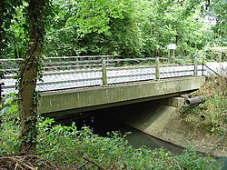
Gatwick Stream
Gatwick Stream is a tributary of the River Mole in southern England. It rises in Worth Forest below Clays lake in West Sussex, flows northwards through Tilgate Forest, alongside Tilgate golf course, through Maidenbower, Three Bridges, and Tinsley Green to meet River Mole.

Providence Chapel, Charlwood
Providence Chapel (founded as Charlwood Union Chapel) is a former Nonconformist place of worship in the village of Charlwood in the English county of Surrey. Founded in 1816, it was associated with Independent Calvinists and Strict Baptists throughout nearly two centuries of religious use. English Heritage has listed it at Grade II* for its architectural and historical importance.

Lowfield Heath Windmill
Lowfield Heath Windmill is a grade II listed post mill at Charlwood, Surrey, England. The mill has been restored to working order.
Visit Charlwood plaques
 2
2
plaques
here Charlwood has 2 physical plaques in tourist plaque schemes for you to explore via Walkfo Charlwood plaques audio map when visiting. Plaques like National Heritage’s “Blue Plaques” provide visual geo-markers to highlight points-of-interest at the places where they happened – and Walkfo’s AI has researched additional, deeper content when you visit Charlwood using the app. Experience the history of a location when Walkfo local tourist guide app triggers audio close to each Charlwood plaque. Explore Plaques & History has a complete list of Hartlepool’s plaques & Hartlepool history plaque map.


 Trying to encourage visitors to Charlwood?