Welcome to Visit Carlisle Places
The Walkfo guide to things to do & explore in Carlisle
 Visit Carlisle places using Walkfo for free guided tours of the best Carlisle places to visit. A unique way to experience Carlisle’s places, Walkfo allows you to explore Carlisle as you would a museum or art gallery with audio guides.
Visiting Carlisle Walkfo Preview
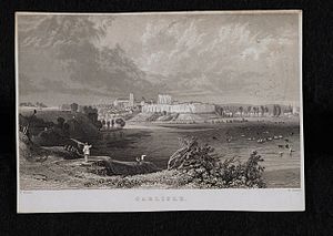
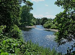
Carlisle is a border city and the county town of Cumbria, as well as the administrative centre of the City of Carlisle district. It is located 8 miles (13 km) south of the Scottish border at the confluence of the rivers Eden, Caldew and Petteril. At the time of the 2001 census, Carlisle was 71,773, with 100,734 living in the wider city. In the 2011 census, the city’s population had risen to 75,306, with 107,524 living in Carlisle. When you visit Carlisle, Walkfo brings Carlisle places to life as you travel by foot, bike, bus or car with a mobile phone & headphones.
Carlisle Places Overview: History, Culture & Facts about Carlisle
Visit Carlisle – Walkfo’s stats for the places to visit
With 69 audio plaques & Carlisle places for you to explore in the Carlisle area, Walkfo is the world’s largest heritage & history digital plaque provider. The AI continually learns & refines facts about the best Carlisle places to visit from travel & tourism authorities (like Wikipedia), converting history into an interactive audio experience.
Carlisle history
Ancient Carlisle
The earliest recorded inhabitants were the Carvetii tribe of Britons who made up the main population of ancient Cumbria and North Lancashire. The Roman settlement was named Luguvalium, based on a native name that has been reconstructed as Brittonic *Luguwaljon, “[city] of Luguwalos”, a masculine Celtic given name meaning “strength of Lugus”
Middle Ages

Carlisle Castle began in 1093 on the site of the Roman fort, south of the River Eden. The castle was rebuilt in stone in 1112, with a keep and the city walls. Carlisle Cathedral was founded as an Augustinian priory and became a cathedral in 1133. By the time of the Norman conquest in 1066, Carlisle was part of Scotland.
Early Modern era
After the Pilgrimage of Grace, Henry VIII employed Stefan von Haschenperg to modernise the defences of Carlisle. The castle was refortified using stone from the cathedral cloisters in 1639. In 1642 the English Civil War broke out and the castle was garrisoned for the king. In 1707 an act of union was passed between England and Scotland, creating Great Britain.
Industrial Revolution

The post of Governor of Carlisle as garrison commander was abolished in 1838. In the early 19th century textile mills, engineering works and food manufacturers built factories in the city. The expanding industries brought about an increase in population as jobs shifted from rural farms towards the cities.
Modern history

In 1916, the government took over the public houses and breweries in Carlisle because of drunkenness among construction and munitions workers from the munitions factory at Gretna. In 1912, the boundaries of Carlisle were extended to include Botcherby in the east and Stanwix in the north. During the Second World War, Carlisle hosted over 5,000 evacuees, many of whom arrived from Newcastle upon Tyne and surrounding towns. In 2005, the rivers Eden, Caldew and Petteril burst their banks due to as much as 180 mm rainfall up stream.
Carlisle culture & places
Art and history

The Tullie House Museum and Art Gallery was opened in 1893 by Carlisle Corporation. The museum features exhibits detailing the history of Roman occupancy of the region. The city’s Guildhall Museum is based in a 14th-century house.
Music and theatre
Carlisle has hosted Europe’s largest free music festival, Radio 1’s Big Weekend. Brunton Park stadium has hosted live music including an Elton John concert in 2007. The defunct Brampton Live, the largest folk festival in the north of England, formerly took place in Brampton.
Gastronomy
Every August the Carlisle Food Fair is held in the pedestrianised area of the city centre. It plays host to produce from across the continent and features local produce.
Media
From 1961 to 2009 Carlisle was home to Border Television which served the ITV Border region. No regular TV news programmes were made in North Cumbria from 2010 to 2014. A 15-minute news opt-out was provided by ITV Tyne Tees in Gateshead.
Carlisle geography / climate
Carlisle is situated on a slight rise, in the Cumberland Ward, at the confluence of the rivers Eden, Caldew and Petteril. It is located 56 miles (90 km) west of Newcastle upon Tyne, 71 miles (114 km) north of Lancaster, 90 miles (140 km) south-east of Glasgow, 93 miles (150km) south of Edinburgh, 120 miles (190km) north-west of York. Nearby towns and villages include Longtown (north), Penrith (south) Brampton (east), Wigton (west), Haggbeck, Harker, Carwinley and Houghton.
Climate
Carlisle experiences an oceanic climate (Köppen climate classification Cfb) In January 2005 Carlisle was hit by strong gales and heavy rain, and on Saturday 8 January 2005 all roads into Carlisle were closed owing to severe flooding. Less serious but still significant flooding happened in 2009, but due to Storm Desmond, even worse flooding than 2005 badly affected Carlisle between Friday 4 and Sunday 6 December 2015.
Divisions and suburbs

In the north of Carlisle are the suburbs of Kingstown, Lowry Hill and Moorville, formerly part of the parish of Kingmoor. Stanwix, Edentown, Etterby, St Ann’s Hill and Belah were added to Carlisle in 1912. The suburbs of Newtown, Morton, Sandsfield Park, Longsowerby, Raffles and Belle Vue developed in the late 19th and 20th century.
Why visit Carlisle with Walkfo Travel Guide App?
 You can visit Carlisle places with Walkfo Carlisle to hear history at Carlisle’s places whilst walking around using the free digital tour app. Walkfo Carlisle has 69 places to visit in our interactive Carlisle map, with amazing history, culture & travel facts you can explore the same way you would at a museum or art gallery with information audio headset. With Walkfo, you can travel by foot, bike or bus throughout Carlisle, being in the moment, without digital distraction or limits to a specific walking route. Our historic audio walks, National Trust interactive audio experiences, digital tour guides for English Heritage locations are available at Carlisle places, with a AI tour guide to help you get the best from a visit to Carlisle & the surrounding areas.
“Curated content for millions of locations across the UK, with 69 audio facts unique to Carlisle places in an interactive Carlisle map you can explore.”
Walkfo: Visit Carlisle Places Map
69 tourist, history, culture & geography spots
Carlisle historic spots | Carlisle tourist destinations | Carlisle plaques | Carlisle geographic features |
| Walkfo Carlisle tourism map key: places to see & visit like National Trust sites, Blue Plaques, English Heritage locations & top tourist destinations in Carlisle | |||
Best Carlisle places to visit
Carlisle has places to explore by foot, bike or bus. Below are a selection of the varied Carlisle’s destinations you can visit with additional content available at the Walkfo Carlisle’s information audio spots:
| University of Cumbria The University of Cumbria opened its doors in 2007. It has its headquarters in Carlisle and other major campuses in Lancaster, Ambleside, and London. |
 | Cumbria House Cumbria House is a municipal building in Botchergate, Carlisle. It is the headquarters of the Cumbrian County Council. |
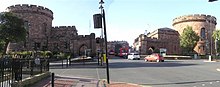 | Carlisle Citadel Carlisle Citadel or The Citadel is a former medieval fortress on English Street in Carlisle, Cumbria. It comprises two towers, the Nisi Prius Courthouse and the former Crown Court. |
 | Carlisle Civic Centre Carlisle Civic Centre is a municipal building in Carlisle, England. It is located in the Rickergate, Carlisle. The Civic Centre was built in the 1960s. |
 | Old Town Hall, Carlisle The Old Town Hall is a Grade I listed building in Carlisle, England. It is a municipal building in the Market Place, Carlisle. |
 | Carlisle Guildhall Carlisle Guildhall is an historic building in Carlisle, Cumbria. It is a Grade I listed building, listed on 1 June 1949. The upper floors now house a museum. |
 | Carlisle Tithe Barn Carlisle Tithe Barn is an historic building in Carlisle, Cumbria. It is Grade I listed building, listed on 1 June 1949. |
 | Milecastle 65 Milecastle 65 (Tarraby) was a milecastle on Hadrian’s Wall (grid reference NY40855793) Mile Castle 65 was located in Tarraby. |
 | Milecastle 66 Milecastle 66 (Stanwix Bank) was a milecastle on Hadrian’s Wall (grid reference NY39735678) Milecastle was built in the early Roman era. |
 | Hadrian’s Camp Hadrian’s Camp was a military installation on the line of Hadrian’s Wall at Houghton in Cumbria, England. |
Visit Carlisle plaques
 4
4
plaques
here Carlisle has 4 physical plaques in tourist plaque schemes for you to explore via Walkfo Carlisle plaques audio map when visiting. Plaques like National Heritage’s “Blue Plaques” provide visual geo-markers to highlight points-of-interest at the places where they happened – and Walkfo’s AI has researched additional, deeper content when you visit Carlisle using the app. Experience the history of a location when Walkfo local tourist guide app triggers audio close to each Carlisle plaque. Explore Plaques & History has a complete list of Hartlepool’s plaques & Hartlepool history plaque map.


 Trying to encourage visitors to Carlisle?