Welcome to Visit Bredbury Places
The Walkfo guide to things to do & explore in Bredbury
 Visit Bredbury places using Walkfo for free guided tours of the best Bredbury places to visit. A unique way to experience Bredbury’s places, Walkfo allows you to explore Bredbury as you would a museum or art gallery with audio guides.
Visiting Bredbury Walkfo Preview
Bredbury is 7.9 miles (12.7 km) south-east of Manchester and 1.8 miles (2.9 km) east of Stockport. At the 2011 census, it had a population of 16,721. It is on the lower southern slopes of Werneth Low, an outlier of the Peak District. When you visit Bredbury, Walkfo brings Bredbury places to life as you travel by foot, bike, bus or car with a mobile phone & headphones.
Bredbury Places Overview: History, Culture & Facts about Bredbury
Visit Bredbury – Walkfo’s stats for the places to visit
With 83 audio plaques & Bredbury places for you to explore in the Bredbury area, Walkfo is the world’s largest heritage & history digital plaque provider. The AI continually learns & refines facts about the best Bredbury places to visit from travel & tourism authorities (like Wikipedia), converting history into an interactive audio experience.
Bredbury history
Iron Age
The area must have been unattractive to the Brigantes settlers in pre-Roman Britain. The rivers flowed more fully before their waters were dammed in the 19th century. However, where the valley of the River Goyt narrows at New Bridge, passage was possible.
Roman occupation
The name ‘Bredbury’ is Anglo-Saxon and probably dates from the first permanent settlement, likely a fortification. Names found in nearby villages suggest that Norse invaders found their way into the district, probably during the 10th century.
Middle Ages
Bredbury comprised farm land bought by Lord Danton in 1014. There is no mention of Lord Danton’s manor, but the ‘lord’ of Bredbury was the pre-conquest Anglo-Saxon thane, Wulfric. It is likely that William the Conqueror’s army, on its march from Yorkshire to subdue the rebellion at Chester, followed the main highway. Virtually all the townships on the way were systematically looted, part of the Harrying of the North. Bredbury seems to have been an exception, for reasons which are unclear, but the army apparently crossed the hill into Romiley, which although not on the direct route, is duly described as “waste” in the Domesday Book of 1086. Bredbury itself was mentioned briefly in the Domesday Book as being several hundred acres of land. The only occupants listed were a duck and a sheep. Its value was placed at three pounds. Bredbury passed from the hands of Sir Richard de Vernon to the Mascis of Dunham, under whom it was held by the Fitz-Waltheofs of Stockport. A charter granted by the third Hamon de Masci, lord of Dunham, who died about the end of the reign of King John, confirms the ownership of lands in Bredbury to the Fitz-Waltheofs, and is of special interest because it affords an insight into the working of the feudal system of the period. A translation of the charter runs as follows: And I, Hamo, regrant to Robert, the son of Waltheof, Bredbury and Brinnington, with their appurtenances, as his inheritance, to him and his heirs, to hold of me and my heirs, by the service of carrying my bed, my arms or my clothing, whenever the Earl of Chester in his own proper person shall go to Wales. And I, Hamo, will fully furnish Robert, the sone of Waltheof, and his heirs, with a sumpter beast and a man and a sack, and we will find estovers (sufficient food) whilst he is with us in the field, until he shall be returned, to the said Robert or his heirs. And Robert, the son of Waltheof, shall pay to ransom my body from captivity and detention, and to make my eldest son a knight, and to give my eldest daughter a marriage portion, in consideration of which Robert has given me a gold ring. The conditions laid down in this charter were usual under the feudal system, when military expeditions into Wales were no uncommon tasks for the Earl of Chester and his underlords. By a general inquisition of tenures, taken 10 May 1288, to determine the services due to Edward I in the Welsh Wars, it was found that “Richard de Stokeport holds Bredbury of Hamo de Masci” and “makes service to our Lord the King with one uncaparisoned horse”. Some time during the 14th century the manor of Bredbury was sub-divided into two portions, the larger of which was held by the Bredburys, and passed from them, by marriage with an heiress, to the Ardernes. The remaining portion ultimately came into the possession of the Davenports of Henbury. It would appear, however, that the manor of Bredbury was still held by the Stokeports, for in the inquisition post mortem of Isabel, daughter and heiress of Sir Richard de Stokeport, taken in 1370, it was found that the manor of Bredbury, with its appurtenances, was held from Roger Lestrange, lord of Dunham Massey, by knight’s service, and that it was worth 100 shillings per annum. In the same year, another inquisition was taken on the death of Hugh de Davenport, which records that he died “seised of two parts of the manor of Bredbury, and of land in Romiley and Werneth” and that Thomas de Davenport was his son and heir, aged 12 years. These lands remained in the possession of the Davenports for several generations The manor house of the Davenports in Bredbury was Goyt Hall on the banks of the River Goyt. During the Middle Ages the wealth of the Kingdom of England arose largely from the export of wool to the Netherlands, but the district had no share in this prosperity. By Tudor times, however, conditions had changed. Continental trade had been ruined by the Dutch War of Independence and home production of cloth was encouraged. By this time too, the wolves of Longdendale had been exterminated. Great flocks of sheep grazed on the moors and hillsides of the district, sheep farmers and weavers prospered, and established families such as the Ardernes and, at nearby Marple, the Bradshaws became wealthy and influential. The local industries based on thesheep farming, in the absence of ready water power, remained domestic – mainly handloom weaving and the making of felt hats.
Modern era
The main road continued to be of importance, particularly for the transport of salt from Cheshire, throughout medieval times. In the 17th century there were as many as twelve smithies in Bredbury. The district was until late in the 19th century little more than a group of hamlets, but the Industrial Revolution brought a number of cotton mills.
Industrial Revolution
The Peak Forest Canal opened in sections in the 1790s and first decade of the 19th century. It provided a water supply and the transport of raw materials, fuel and finished products for the new mills. The coming of the railways led to further industrial development, a steady growth of population and the fusing of the separate settlements into the village.
20th century
In the 1930s, and after the Second World War, the growth rate accelerated with the coming of new industries, including engineering, chemicals, clothing and textiles. The village became an important residential area on the periphery of the Greater Manchester Urban Area. Comprehensive sewerage and sewage disposal services were completed in 1938.
Bredbury landmarks
The village has extensive areas of attractive countryside, both in the river valleys and on the slopes of Werneth Low. The village is located in the River Valley and the Wanneth Low, and is located on the south side of the River River.
Arden Hall

The most famous of the halls of Bredbury, Arden Hall, erected in 1597, is now a ruin. For over two centuries it was owned by the Ardernes, a junior branch of the Arden family of Warwickshire, of whom William Shakespeare’s mother was a member. Oliver Cromwell stayed at the hall and there was a skirmish nearby.
Bredbury Hall
Bredbury Hall, approached from Dark Lane, has been so altered as to have lost every vestige of its former appearance. In 1638, the hall was occupied by a branch of the Davenports, a connection of the Bredburys. In the 19th century, it was rebuilt, and converted into a family residence in the Georgian style.
Bredbury Library
The original library on George Lane opened in 1937, and the capacity was doubled by extensions in 1962. The latter, now used as a community meeting room, is a dodecahedral annexe, erected as a War Memorial for the Second World War.
Bredbury Old School
Erected at School Brow in 1780 by John Arden, Lord of the Manor, and the freeholders of the township of Bredbury, on land enclosed from the Common of Barrack Hill. Trustee was to “appoint a proper and sufficient person to be Schoolmaster” The building of larger schools and the passing of the Education Acts rendered it obsolete.
Goyt Hall

Goyt Hall is a half-timbered building erected by Randal Davenport about the year 1570. The marriage of the last of the Davenports in 1664 brought the hall into the possession of Sir Fulke Lucy, a kinsman of Sir Thomas Lucy who features in the story of William Shakespeare’s youth.
Harrytown Hall
Harrytown Hall dates from 1671, and is well preserved in spite of being Gothicised during the Romantic Revival. Formerly occupied by the Convent of the Nativity of the Sisters of Charity of Notre Dame d’Évron.
Why visit Bredbury with Walkfo Travel Guide App?
 You can visit Bredbury places with Walkfo Bredbury to hear history at Bredbury’s places whilst walking around using the free digital tour app. Walkfo Bredbury has 83 places to visit in our interactive Bredbury map, with amazing history, culture & travel facts you can explore the same way you would at a museum or art gallery with information audio headset. With Walkfo, you can travel by foot, bike or bus throughout Bredbury, being in the moment, without digital distraction or limits to a specific walking route. Our historic audio walks, National Trust interactive audio experiences, digital tour guides for English Heritage locations are available at Bredbury places, with a AI tour guide to help you get the best from a visit to Bredbury & the surrounding areas.
“Curated content for millions of locations across the UK, with 83 audio facts unique to Bredbury places in an interactive Bredbury map you can explore.”
Walkfo: Visit Bredbury Places Map
83 tourist, history, culture & geography spots
Bredbury historic spots | Bredbury tourist destinations | Bredbury plaques | Bredbury geographic features |
| Walkfo Bredbury tourism map key: places to see & visit like National Trust sites, Blue Plaques, English Heritage locations & top tourist destinations in Bredbury | |||
Best Bredbury places to visit
Bredbury has places to explore by foot, bike or bus. Below are a selection of the varied Bredbury’s destinations you can visit with additional content available at the Walkfo Bredbury’s information audio spots:

Marple Aqueduct
Marple Aqueduct at Marple, Greater Manchester, is the highest canal aqueduct in England. It was built to carry the lower level of the Peak Forest Canal across the River Goyt. Seven men lost their lives during its construction. The difference in water levels in the river and canal is 90 feet (27.4m) It contains 8,000 cubic yards (6,000 m³) of masonry.

Brabyns Park
Brabyns Park is a public park in Marple Bridge, Stockport, Greater Manchester, England. It is located on the outskirts of the city of Stockport.

Chadkirk
Chadkirk is an area in the Metropolitan Borough of Stockport in Greater Manchester. It is located between the River Goyt and the Peak Forest Canal south of Romiley, east of the A627 road. The site of a former print works on the right bank of the river is now a business park. The ancient woodlands of Kirk Wood and Little Wood have been declared Sites of Biological Importance (SBI)

Chadkirk Chapel
Chadkirk Chapel is a restored historic chapel near Romiley in the Metropolitan Borough of Stockport in Greater Manchester. It is recorded in the National Heritage List for England as a designated Grade II* listed building.

Elder Mill, Romiley
Elder Mill, Romiley was a cotton spinning mill in Romiley, Stockport, Greater Manchester. It was taken over by the Lancashire Cotton Corporation in the 1930s and passed to Courtaulds in 1964.

Denton Town Hall
Denton Town Hall is a municipal building in the Market Street, Denton, Greater Manchester. The town hall, which is the meeting place of the Denton Council, is now a public library.

St George’s Church, Hyde
St George’s Church is on Church Street, Hyde, Greater Manchester. It is an active Anglican parish church in the deanery of Mottram, the archdeaconry of Macclesfield and the diocese of Chester. The church is recorded in the National Heritage List for England as a designated Grade II listed building.

Palmer Mills, Stockport
Palmer Mills, Stockport were cotton spinning mills in Portwood, Greater Manchester. Built in the late 19th century, it was taken over by Lancashire Cotton Corporation in the 1930s and sold on. Renamed the Stockport Paper Mill they survived into the 21st century when they were demolished to be replaced by modern businesses.
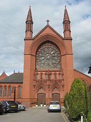
Our Lady and the Apostles Church, Stockport
Our Lady and the Apostles Church is a Roman Catholic Parish church in the Edgeley area of Stockport, Greater Manchester. It was built from 1903 to 1905 and replaced St Philip and St James Church, built in 1803, which was the first permanent Catholic church to be built in Stockport after the English Reformation.
Stockport Castle
Stockport Castle was a promontory castle in the medieval town overlooking a ford over the River Mersey. It was first documented in 1173, but the next mention of it is in 1535 when it was in ruins. What remained of the castle was demolished in 1775.
Visit Bredbury plaques
 18
18
plaques
here Bredbury has 18 physical plaques in tourist plaque schemes for you to explore via Walkfo Bredbury plaques audio map when visiting. Plaques like National Heritage’s “Blue Plaques” provide visual geo-markers to highlight points-of-interest at the places where they happened – and Walkfo’s AI has researched additional, deeper content when you visit Bredbury using the app. Experience the history of a location when Walkfo local tourist guide app triggers audio close to each Bredbury plaque. Explore Plaques & History has a complete list of Hartlepool’s plaques & Hartlepool history plaque map.


 Trying to encourage visitors to Bredbury?