Welcome to Visit Bonnyrigg Places
The Walkfo guide to things to do & explore in Bonnyrigg
 Visit Bonnyrigg places using Walkfo for free guided tours of the best Bonnyrigg places to visit. A unique way to experience Bonnyrigg’s places, Walkfo allows you to explore Bonnyrigg as you would a museum or art gallery with audio guides.
Visiting Bonnyrigg Walkfo Preview
Bonnyrigg is eight miles (13 kilometres) southeast of Edinburgh city centre. The town had a population of 14,663 in the 2001 census which rose to 15,677 in the 2011 census. The estimated population for 2018 is 18,120, the highest of any town in Midlothian. When you visit Bonnyrigg, Walkfo brings Bonnyrigg places to life as you travel by foot, bike, bus or car with a mobile phone & headphones.
Bonnyrigg Places Overview: History, Culture & Facts about Bonnyrigg
Visit Bonnyrigg – Walkfo’s stats for the places to visit
With 40 audio plaques & Bonnyrigg places for you to explore in the Bonnyrigg area, Walkfo is the world’s largest heritage & history digital plaque provider. The AI continually learns & refines facts about the best Bonnyrigg places to visit from travel & tourism authorities (like Wikipedia), converting history into an interactive audio experience.
Bonnyrigg history

Bonnyrigg first appears as a small hamlet on William Roy’s map of c.1750 as Bonnebrig. From 1763, it is called Bannockrigg or Bannoc Rig. The Ordnance Survey map of 1850-1852 standardises the name as Bonnryigg. In 1865, the villages of Bonnyrig, Red Row, Polton Street, Hillhead and Broomieknowe combined to form the. In 1881, the village of Lasswade and part of the. Lassawade & Bonnnyrrig formed the. burgh of. the. town centre.
Why visit Bonnyrigg with Walkfo Travel Guide App?
 You can visit Bonnyrigg places with Walkfo Bonnyrigg to hear history at Bonnyrigg’s places whilst walking around using the free digital tour app. Walkfo Bonnyrigg has 40 places to visit in our interactive Bonnyrigg map, with amazing history, culture & travel facts you can explore the same way you would at a museum or art gallery with information audio headset. With Walkfo, you can travel by foot, bike or bus throughout Bonnyrigg, being in the moment, without digital distraction or limits to a specific walking route. Our historic audio walks, National Trust interactive audio experiences, digital tour guides for English Heritage locations are available at Bonnyrigg places, with a AI tour guide to help you get the best from a visit to Bonnyrigg & the surrounding areas.
“Curated content for millions of locations across the UK, with 40 audio facts unique to Bonnyrigg places in an interactive Bonnyrigg map you can explore.”
Walkfo: Visit Bonnyrigg Places Map
40 tourist, history, culture & geography spots
Bonnyrigg historic spots | Bonnyrigg tourist destinations | Bonnyrigg plaques | Bonnyrigg geographic features |
| Walkfo Bonnyrigg tourism map key: places to see & visit like National Trust sites, Blue Plaques, English Heritage locations & top tourist destinations in Bonnyrigg | |||
Best Bonnyrigg places to visit
Bonnyrigg has places to explore by foot, bike or bus. Below are a selection of the varied Bonnyrigg’s destinations you can visit with additional content available at the Walkfo Bonnyrigg’s information audio spots:
 | National Mining Museum Scotland The National Mining Museum Scotland was created in 1984 to preserve the physical surface remains of Lady Victoria Colliery at Newtongrange, Midlothian, Scotland. The colliery, sunk by the Lothian Coal Company in 1890, came into production in 1894. It was nationalised in 1947 and closed in 1981. |
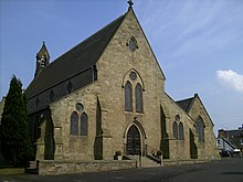
 | Cockpen and Carrington Parish Church Cockpen and Carrington Parish Church is located to the south of the town of Bonnyrigg in Midlothian, Scotland. It is a congregation of the Church of Scotland. The current arrangement dates from 1975, when the two churches were united. The church’s tower is unusually tall for a comparatively small church and its design was copied for Kilconquhar Parish Church in Fife. |
 | St David’s Church, Dalkeith St David’s Church was founded in 1854 by Cecil Chetwynd Kerr, Marchioness of Lothian. It was designed by Joseph Hansom and is a category A listed building. |
 | Melville Castle Melville Castle is a three-storey Gothic castellated mansion situated less than a mile (2 km) west-south-west of Dalkeith, Midlothian, near the North Esk. |
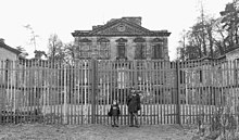 | Mavisbank House Mavisbank is a country house outside Loanhead, south of Edinburgh in Midlothian, Scotland. It was designed by William Adam, in collaboration with his client, Sir John Clerk of Penicuik, and was constructed between 1723 and 1727. The house was altered in the 19th century, but suffered decades of neglect in the 20th century. The interiors were gutted by fire in 1973, and the house remains a ruin. |
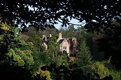 | Hawthornden Castle Hawthornden Castle is located on the River North Esk in Midlothian, Scotland. Man-made caves in the rock beneath the castle have been in use for much longer than castle itself. |
Visit Bonnyrigg plaques
 2
2
plaques
here Bonnyrigg has 2 physical plaques in tourist plaque schemes for you to explore via Walkfo Bonnyrigg plaques audio map when visiting. Plaques like National Heritage’s “Blue Plaques” provide visual geo-markers to highlight points-of-interest at the places where they happened – and Walkfo’s AI has researched additional, deeper content when you visit Bonnyrigg using the app. Experience the history of a location when Walkfo local tourist guide app triggers audio close to each Bonnyrigg plaque. Explore Plaques & History has a complete list of Hartlepool’s plaques & Hartlepool history plaque map.


 Trying to encourage visitors to Bonnyrigg?