Welcome to Visit Boldmere Places
The Walkfo guide to things to do & explore in Boldmere
 Visit Boldmere places using Walkfo for free guided tours of the best Boldmere places to visit. A unique way to experience Boldmere’s places, Walkfo allows you to explore Boldmere as you would a museum or art gallery with audio guides.
Visiting Boldmere Walkfo Preview
When you visit Boldmere, Walkfo brings Boldmere places to life as you travel by foot, bike, bus or car with a mobile phone & headphones.
Boldmere Places Overview: History, Culture & Facts about Boldmere
Visit Boldmere – Walkfo’s stats for the places to visit
With 82 audio plaques & Boldmere places for you to explore in the Boldmere area, Walkfo is the world’s largest heritage & history digital plaque provider. The AI continually learns & refines facts about the best Boldmere places to visit from travel & tourism authorities (like Wikipedia), converting history into an interactive audio experience.
Boldmere history
Toponymy
“Boldmere” is a corruption of the word “Baldmoor”, coming from the Middle English bald (meaning “a white patch”) and the Anglo-Saxon moor . Therefore, Boldmere literally means a “bald moor”; a treeless patch .
Expansion
On introduction of the 1825 Inclosure Act, the area saw little expansion due to common land becoming privately owned . The 1841 census listed eight families in the area, including agricultural workers, a painter, an Irish carrier, and a wire drawer .
Boldmere economy & business
Industry
Powell’s Pool (then known as New Forge Pool) near Boldmere Gate was the site of the mill used by John Wyatt to experiment with mechanised cotton spinning . In 1750, the mill was used by William Powell to manufacture spades (using locally-grown ash wood for the handles) It is believed that the first steel garden fork was manufactured at the mill . The building was later used to produce steel for the production of pen nibs .
Boldmere geography / climate

Boldmere is triangular in shape and roughly bounded on the north by Sutton Park, on the east by the Cross-City railway line and on the south-west by Chester Road. Boldmere Gate provides access to Sutton Park.
Why visit Boldmere with Walkfo Travel Guide App?
 You can visit Boldmere places with Walkfo Boldmere to hear history at Boldmere’s places whilst walking around using the free digital tour app. Walkfo Boldmere has 82 places to visit in our interactive Boldmere map, with amazing history, culture & travel facts you can explore the same way you would at a museum or art gallery with information audio headset. With Walkfo, you can travel by foot, bike or bus throughout Boldmere, being in the moment, without digital distraction or limits to a specific walking route. Our historic audio walks, National Trust interactive audio experiences, digital tour guides for English Heritage locations are available at Boldmere places, with a AI tour guide to help you get the best from a visit to Boldmere & the surrounding areas.
“Curated content for millions of locations across the UK, with 82 audio facts unique to Boldmere places in an interactive Boldmere map you can explore.”
Walkfo: Visit Boldmere Places Map
82 tourist, history, culture & geography spots
Boldmere historic spots | Boldmere tourist destinations | Boldmere plaques | Boldmere geographic features |
| Walkfo Boldmere tourism map key: places to see & visit like National Trust sites, Blue Plaques, English Heritage locations & top tourist destinations in Boldmere | |||
Best Boldmere places to visit
Boldmere has places to explore by foot, bike or bus. Below are a selection of the varied Boldmere’s destinations you can visit with additional content available at the Walkfo Boldmere’s information audio spots:

Gravelly Hill
Gravelly Hill is an area of Birmingham, United Kingdom . It is a small part of the Birmingham city centre of the city . It was also known as Gravelly Hills in the 1960s .

Short Heath, Birmingham
Short Heath is an area of Birmingham, England near to Erdington . The area’s postcode is B23. The area is near Erdington and Short Heath .

Perry Common
Perry Common is an area of north Birmingham that includes parts of Stockland Green and Kingstanding . It falls within the Birmingham Erdington parliamentary constituency .

Witton Cemetery
Witton Cemetery opened in 1863 as Birmingham City Cemetery . Covering 103 acres (0.42 km), it once had three chapels . Two of these were demolished in 1980 . The cemetery would perform up to 20 burials a day .

Fort Dunlop
Fort Dunlop (grid reference SP129902), is the name of the original tyre factory . It was established in 1917, and by 1954 the entire factory area employed 10,000 workers . At one time it was the world’s largest factory .

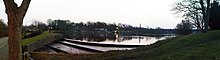
Sutton Park, West Midlands
Sutton Park is a large urban park located in Sutton Coldfield, Birmingham, West Midlands . Most of the park is a national nature reserve; large parts are also a scheduled monument . The park consists of a mix of heathland, wetlands and marshes, seven lakes and extensive ancient woodlands .
![]()
OpenStreetMap Foundation
The OpenStreetMap Foundation (abbreviated OSMF) is a non-profit foundation whose aim is to support and enable the development of freely-reusable geospatial data. Its constitution does not prevent it supporting other projects.

Romulus F.C.
Romulus Football Club is a football club based in Castle Vale, Birmingham, England. The club was formed in 1979 by club president Roger Evans, initially the team played Sunday league football. First team play in the Midland League Premier Division.

Sutton Trinity (ward)
Sutton Trinity is one of the 40 electoral wards in Birmingham. It is named after Holy Trinity Church, the town’s parish church. It was created on 10 June 2004 following a Boundary Commission review of the city.

Sutton Coldfield power station
Sutton Coldfield power station supplied electricity to the town from 1901 to 1959. It was closed in 1959 when it had a generating capacity of 1.0 MW.
Visit Boldmere plaques
 15
15
plaques
here Boldmere has 15 physical plaques in tourist plaque schemes for you to explore via Walkfo Boldmere plaques audio map when visiting. Plaques like National Heritage’s “Blue Plaques” provide visual geo-markers to highlight points-of-interest at the places where they happened – and Walkfo’s AI has researched additional, deeper content when you visit Boldmere using the app. Experience the history of a location when Walkfo local tourist guide app triggers audio close to each Boldmere plaque. Explore Plaques & History has a complete list of Hartlepool’s plaques & Hartlepool history plaque map.


 Trying to encourage visitors to Boldmere?