Welcome to Visit Betchworth Places
The Walkfo guide to things to do & explore in Betchworth
 Visit Betchworth places using Walkfo for free guided tours of the best Betchworth places to visit. A unique way to experience Betchworth’s places, Walkfo allows you to explore Betchworth as you would a museum or art gallery with audio guides.
Visiting Betchworth Walkfo Preview
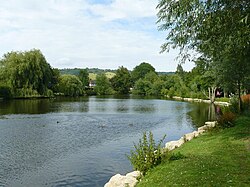
Betchworth is a village and civil parish in the Mole Valley district of Surrey. The village centre is on the north bank of the River Mole and south of the A25 road, almost 3 miles (4.8 km) east of Dorking. A former lime quarry, rebuilt manor house and Grade I-listed church are within its boundaries. When you visit Betchworth, Walkfo brings Betchworth places to life as you travel by foot, bike, bus or car with a mobile phone & headphones.
Betchworth Places Overview: History, Culture & Facts about Betchworth
Visit Betchworth – Walkfo’s stats for the places to visit
With 24 audio plaques & Betchworth places for you to explore in the Betchworth area, Walkfo is the world’s largest heritage & history digital plaque provider. The AI continually learns & refines facts about the best Betchworth places to visit from travel & tourism authorities (like Wikipedia), converting history into an interactive audio experience.
Betchworth history
Etymology
State records show the name Becesworde, (11th century), Beceswrde, (12th century) and Bechesworth, (13th century). State records state the name as Beceswordsworde or Bechesworde. Becheswordsworth was also known as Becheswrde or Beceswwrde.
Pre-Roman settlement
Bronze Age artefacts have been found at Betchworth only since 1944. No Roman villas, farms or camps have been discovered at the site.
Medieval period
Betchworth lay within the Wotton hundred and appears in two entries in the Domesday Book as Becesworde, held by Richard Fitz Gilbert, Richard de Tonebrige. A distinct part named Thorncroft is mentioned in the first listing which was split by five overlords in 1066 before the conquest. The east of the village became part of Reigate hundred.
Post-Reformation
A manorial system continued for a long period in this village. Great tithes were commuted for £295 15s 4d, and the vicarial (lesser tithes) for £20.
Post-Industrial Revolution
A school was endowed with £20 per annum as at 1848 four other significant endowment charities existed then and continued though were less significant due to inflation through to 1911 for the benefit of the poor.
Betchworth lime quarries

To supply the cement for construction associated with required brick built housing, a rich seam of suitable chalk and limestone was identified in the North Downs. Broome Park estate, extending to the top of the hill, included some of these quarries. Six of the lime kilns along the Pilgrims’ Way footpath in Betchworth are Scheduled Ancient Monuments.
Betchworth landmarks
Betchworth Conservation Area contains 22 listed buildings and the church of St Michael, the only Grade I Grade I building. The area contains the only grade I building in the Conservation Area.
Betchworth Castle
The ruins of Betchworth Castle are a couple of miles west of the town in the west of Brockham civil parish. The ruins are located in the east of the village of Brockham, in Brockham, and in the south of the civil parish of Betchworth.
St Michael’s Church
Most of the church on the Betchworth site now occupied by St Michael’s dates to the early 13th century. In a pillar of the tower’s south window, there remains a fragment of the stone Saxon church. The south aisle chapel became known as the Hope Chapel after Henry Thomas Hope bought the Manor in 1838.
Betchworth House
Architecturally Grade II*-listed Betchworth House is the largest building in the village, excluding Hartsfield Manor Hotel on the opposite bank of the Sloughs brook. Erected by the Freeman local Lords of the Manor after Ralph Freeman, judge, auditor and tin trader bought the manor in 1629 which the House replaced. It was extended and re-faced in 1808 and again in 1820.
Broome Park
Broome Park is a Grade II listed early 19th century home. It was the home of Sir Benjamin Brodie, the royal physician. After his death in 1862, it was sold to General Sir Percy R. B. Feilding, son of the 7th Earl of Denbigh.
Betchworth geography / climate
Location
Betchworth is 20 miles (32 km) south of London, in the outer London commuter belt. The village is 3 miles (4.8 km) east of Dorking and 3 miles west of Reigate.
Elevation
Elevations range from 216 m at the water tower, which marks the highest point of the parish on Box Hill, down to the River Mole, which runs east–west through the village. Between these extremes the landscape is mainly undulating, except for the steep chalk face of the North Downs.
Geology & Soil
Mammoth fossilised bone remains have been found below flint beds under considerable clay in the low hills by the bank of the River Mole in Betchworth. Most of the parish has free draining slightly acid loamy soil.
Demography & Housing
98.5% of the population identified as white, 0.7% as mixed and 1.3% as one of the four main categories (five including mixed) Betchworth comprised 372 households and 12 vacant houses, shops and country businesses such as stone merchants and garden centres.
Economy
Betchworth’s economy is predominantly a service sector economy. Cleaning and gardening companies find a strong local market. The former lime quarry is managed by workers from Surrey Wildlife Trust and English Heritage.
Why visit Betchworth with Walkfo Travel Guide App?
 You can visit Betchworth places with Walkfo Betchworth to hear history at Betchworth’s places whilst walking around using the free digital tour app. Walkfo Betchworth has 24 places to visit in our interactive Betchworth map, with amazing history, culture & travel facts you can explore the same way you would at a museum or art gallery with information audio headset. With Walkfo, you can travel by foot, bike or bus throughout Betchworth, being in the moment, without digital distraction or limits to a specific walking route. Our historic audio walks, National Trust interactive audio experiences, digital tour guides for English Heritage locations are available at Betchworth places, with a AI tour guide to help you get the best from a visit to Betchworth & the surrounding areas.
“Curated content for millions of locations across the UK, with 24 audio facts unique to Betchworth places in an interactive Betchworth map you can explore.”
Walkfo: Visit Betchworth Places Map
24 tourist, history, culture & geography spots
Betchworth historic spots | Betchworth tourist destinations | Betchworth plaques | Betchworth geographic features |
| Walkfo Betchworth tourism map key: places to see & visit like National Trust sites, Blue Plaques, English Heritage locations & top tourist destinations in Betchworth | |||
Best Betchworth places to visit
Betchworth has places to explore by foot, bike or bus. Below are a selection of the varied Betchworth’s destinations you can visit with additional content available at the Walkfo Betchworth’s information audio spots:
 | Buckland Windmill Buckland Windmill is a grade II listed smock mill at Buckland, Surrey, England. It is the only surviving wind saw mill in the United Kingdom. |
 | Deepdene House and Gardens Deepdene was an estate and country house occupying land to the southeast of Dorking, Surrey, England. The remains of the gardens are Grade II* listed with the adjoining Chart Park. |
 | Pipp Brook The Pipp Brook is a left-bank tributary of the River Mole in Surrey. It rises at two main springs north of Leith Hill on the Greensand Ridge. It descends steeply in a northward direction before flowing eastwards along the Vale of Holmesdale. It discharges into the Mole at Pixham, Surrey. |
| South Park F.C. South Park Football Club are based in Reigate, Surrey. They play in the Isthmian League South Central Division. The club is affiliated to the Surrey County Football Association. |
 | Reigate Heath Windmill Reigate Heath Windmill is thought to be the only windmill in the world which is a consecrated church. Grade II* listed post mill is used as a chapel. |
 | High Ashurst High Ashurst is a large natural site of 56 acres of land in an Area of Outstanding Natural Beauty in North Downs, Surrey. The site has been host to many different people and organisations over the years, but is now prized for its outdoor learning opportunities. |
Visit Betchworth plaques
 0
0
plaques
here Betchworth has 0 physical plaques in tourist plaque schemes for you to explore via Walkfo Betchworth plaques audio map when visiting. Plaques like National Heritage’s “Blue Plaques” provide visual geo-markers to highlight points-of-interest at the places where they happened – and Walkfo’s AI has researched additional, deeper content when you visit Betchworth using the app. Experience the history of a location when Walkfo local tourist guide app triggers audio close to each Betchworth plaque. Currently No Physical Plaques.


 Trying to encourage visitors to Betchworth?