Welcome to Visit Aydon Places
The Walkfo guide to things to do & explore in Aydon
 Visit Aydon places using Walkfo for free guided tours of the best Aydon places to visit. A unique way to experience Aydon’s places, Walkfo allows you to explore Aydon as you would a museum or art gallery with audio guides.
Visiting Aydon Walkfo Preview
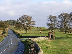
Aydon is about 2 miles (3 km) northeast of Corbridge on the B6321 road. The village is about 18 miles (29 km) from Newcastle along the main A69 road. When you visit Aydon, Walkfo brings Aydon places to life as you travel by foot, bike, bus or car with a mobile phone & headphones.
Aydon Places Overview: History, Culture & Facts about Aydon
Visit Aydon – Walkfo’s stats for the places to visit
With 19 audio plaques & Aydon places for you to explore in the Aydon area, Walkfo is the world’s largest heritage & history digital plaque provider. The AI continually learns & refines facts about the best Aydon places to visit from travel & tourism authorities (like Wikipedia), converting history into an interactive audio experience.
Aydon landmarks
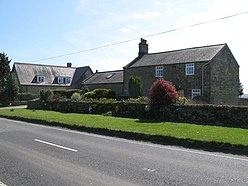
Aydon Castle was built by Robert de Reymes, a wealthy Suffolk merchant, starting in 1296. In 1305 he obtained a licence to crenellate his property and added battlements and curtain walls. In the middle of the 16th century it was renovated and in the 17th century converted into a farm. The building remained in use as a farm until 1966 but has since been restored to its medieval appearance.
Why visit Aydon with Walkfo Travel Guide App?
 You can visit Aydon places with Walkfo Aydon to hear history at Aydon’s places whilst walking around using the free digital tour app. Walkfo Aydon has 19 places to visit in our interactive Aydon map, with amazing history, culture & travel facts you can explore the same way you would at a museum or art gallery with information audio headset. With Walkfo, you can travel by foot, bike or bus throughout Aydon, being in the moment, without digital distraction or limits to a specific walking route. Our historic audio walks, National Trust interactive audio experiences, digital tour guides for English Heritage locations are available at Aydon places, with a AI tour guide to help you get the best from a visit to Aydon & the surrounding areas.
“Curated content for millions of locations across the UK, with 19 audio facts unique to Aydon places in an interactive Aydon map you can explore.”
Walkfo: Visit Aydon Places Map
19 tourist, history, culture & geography spots
Aydon historic spots | Aydon tourist destinations | Aydon plaques | Aydon geographic features |
| Walkfo Aydon tourism map key: places to see & visit like National Trust sites, Blue Plaques, English Heritage locations & top tourist destinations in Aydon | |||
Best Aydon places to visit
Aydon has places to explore by foot, bike or bus. Below are a selection of the varied Aydon’s destinations you can visit with additional content available at the Walkfo Aydon’s information audio spots:

Devil’s Water
Devil’s Water is a tributary of the River Tyne. It joins the River from the south, near the village of Dilston. It is formed from the waters of several smaller burns and sikes between Embley and Hackford some 5 miles south of Hexham.
Milecastle 20
Milecastle 20 (Halton Shields) was one of the milecastles on Hadrian’s Wall (grid reference NZ01886868) It is situated in the hamlet of Halton Shields, and was excavated in 1935.

Milecastle 19
Milecastle 19 (Matfen Piers) was a milecastle of the Roman Hadrian’s Wall. The milecastle is today covered by the B6318 Military Road. It is one of the few dedications to a mother goddess found in Roman Britain.
Milecastle 21
Milecastle 21 (Down Hill) was a milecastle of the Roman Hadrian’s Wall. Site was identified by measurement only, as the milecastle’s remains have been totally removed. Site now lies under pasture (and partly beneath the Military Road)
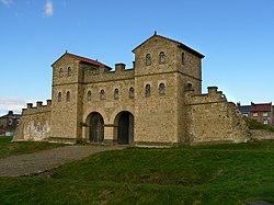
Hunnum
Hunnum (also known as Onnum) was a Roman fort north of the modern-day village of Halton, Northumberland. It was the fifth fort on Hadrian’s Wall, after Segedunum, Pons Aelius, Condercum and Vindobala. The Latinized Brittonic name “Onnum” may mean “Stream/Water”, “Ash (tree)” or “Rock”
Milecastle 22
Milecastle 22 (Portgate) was a milecastle of the Roman Hadrian’s Wall. Its remains exist as a low, turf covered platform just east of the Portgate roundabout.
Portgate
The Portgate was a fortified gateway to control traffic along Dere Street. It was built as part of Hadrian’s Wall where it crossed the Roman road now known as Dere. The gate’s remains exist beneath the old B6318 Military Road to the south-west of Stagshaw Roundabout.
Visit Aydon plaques
 1
1
plaques
here Aydon has 1 physical plaques in tourist plaque schemes for you to explore via Walkfo Aydon plaques audio map when visiting. Plaques like National Heritage’s “Blue Plaques” provide visual geo-markers to highlight points-of-interest at the places where they happened – and Walkfo’s AI has researched additional, deeper content when you visit Aydon using the app. Experience the history of a location when Walkfo local tourist guide app triggers audio close to each Aydon plaque. Explore Plaques & History has a complete list of Hartlepool’s plaques & Hartlepool history plaque map.


 Trying to encourage visitors to Aydon?