Welcome to Visit Agecroft Places
The Walkfo guide to things to do & explore in Agecroft
 Visit Agecroft places using Walkfo for free guided tours of the best Agecroft places to visit. A unique way to experience Agecroft’s places, Walkfo allows you to explore Agecroft as you would a museum or art gallery with audio guides.
Visiting Agecroft Walkfo Preview
Agecroft is a suburban area of Pendlebury, within the City of Salford, Greater Manchester. It lies within the Irwell Valley, on the west bank of the River Irwell and along the course of the Manchester, Bolton & Bury Canal. Agecroft Bridge railway station was a railway station between 1838 and 1861; Agecroft Colliery opened as a commercial coal mine in 1844. When you visit Agecroft, Walkfo brings Agecroft places to life as you travel by foot, bike, bus or car with a mobile phone & headphones.
Agecroft Places Overview: History, Culture & Facts about Agecroft
Visit Agecroft – Walkfo’s stats for the places to visit
With 110 audio plaques & Agecroft places for you to explore in the Agecroft area, Walkfo is the world’s largest heritage & history digital plaque provider. The AI continually learns & refines facts about the best Agecroft places to visit from travel & tourism authorities (like Wikipedia), converting history into an interactive audio experience.
Why visit Agecroft with Walkfo Travel Guide App?
 You can visit Agecroft places with Walkfo Agecroft to hear history at Agecroft’s places whilst walking around using the free digital tour app. Walkfo Agecroft has 110 places to visit in our interactive Agecroft map, with amazing history, culture & travel facts you can explore the same way you would at a museum or art gallery with information audio headset. With Walkfo, you can travel by foot, bike or bus throughout Agecroft, being in the moment, without digital distraction or limits to a specific walking route. Our historic audio walks, National Trust interactive audio experiences, digital tour guides for English Heritage locations are available at Agecroft places, with a AI tour guide to help you get the best from a visit to Agecroft & the surrounding areas.
“Curated content for millions of locations across the UK, with 110 audio facts unique to Agecroft places in an interactive Agecroft map you can explore.”
Walkfo: Visit Agecroft Places Map
110 tourist, history, culture & geography spots
Agecroft historic spots | Agecroft tourist destinations | Agecroft plaques | Agecroft geographic features |
| Walkfo Agecroft tourism map key: places to see & visit like National Trust sites, Blue Plaques, English Heritage locations & top tourist destinations in Agecroft | |||
Best Agecroft places to visit
Agecroft has places to explore by foot, bike or bus. Below are a selection of the varied Agecroft’s destinations you can visit with additional content available at the Walkfo Agecroft’s information audio spots:
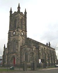
 | Church of the Ascension, Lower Broughton The Church of the Ascension is a Grade II listed Anglican church in Lower Broughton, Salford, England. In February 2017 a fire destroyed the roof and interior of the building. |
 | Wet Earth Colliery Wet Earth Colliery was a coal mine located on the Manchester Coalfield, in Clifton, Greater Manchester. The colliery has a unique place in British coal mining history; apart from being one of the earliest pits in the country, it is the place where engineer James Brindley made water run uphill. |
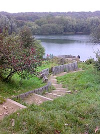 | Clifton Country Park The park comprises 119 acres (48 hectares) of wooded area, fields and lakes. Industrial heritage is also a feature of the park, the remains of Wet Earth Colliery can be found in the woods, along with Fletcher’s Canal. |
 | Pendlebury (ward) Pendlebury is an electoral ward of Salford, England. It is represented in Westminster by Rebecca Long-Bailey MP Rebecca Long Bailey. A profile of the ward conducted in 2014 recorded a population of 13,434. |
 | Irwell Riverside (ward) Irwell Riverside (ward) is an electoral ward of Salford, England. The ward is bounded by meanders of the River Irwell and includes the main university campus. It is represented in Westminster by Rebecca Long-Bailey MP for Salfords and Eccles. |
 | St Thomas’ Church, Pendleton St Thomas’ Church is on Broad Street, Pendleton, Salford, Greater Manchester. It was a Commissioners’ church, having received a grant towards its construction from the Church Building Commission. It is designated by English Heritage as a Grade II listed building. |
 | Greater Manchester Built-up Area The Greater Manchester Built-up Area has a population of 2,553,379 according to the United Kingdom Census 2011. It is the second most populous conurbation in the UK after the Greater London built-up area. The area is not conterminous with Greater Manchester, for it excludes settlements such as Wigan and Marple from Greater Manchester. |
 | HM Prison Forest Bank HM Prison Forest Bank is a Category B men’s private prison. It is located in the Agecroft area of Pendlebury in Salford near Manchester. The prison is operated by Sodexo Justice Services. |
 | Irlams o’ th’ Height Irlams o’ th’ Height is a suburb of Salford, Greater Manchester, England. It is located in the centre of the city’s population. |
 | Salford Acoustics Salford Acoustics is based in two locations: (i) 3 km west of Manchester city centre, UK, and (ii) on the banks of the Manchester Ship Canal at MediaCityUK. It undertakes public and industrial research in acoustics and carries out commercial testing. |
Visit Agecroft plaques
 48
48
plaques
here Agecroft has 48 physical plaques in tourist plaque schemes for you to explore via Walkfo Agecroft plaques audio map when visiting. Plaques like National Heritage’s “Blue Plaques” provide visual geo-markers to highlight points-of-interest at the places where they happened – and Walkfo’s AI has researched additional, deeper content when you visit Agecroft using the app. Experience the history of a location when Walkfo local tourist guide app triggers audio close to each Agecroft plaque. Explore Plaques & History has a complete list of Hartlepool’s plaques & Hartlepool history plaque map.


 Trying to encourage visitors to Agecroft?