Travel to Wells, Somerset Map
Wells, Somerset tourist guide map of landmarks & destinations by Walkfo
 Explore
41
travel
spots
 When travelling to Wells, Somerset, Walkfo’s has created a travel guide & Wells, Somerset overview of Wells, Somerset’s hotels & accommodation, Wells, Somerset’s weather through the seasons & travel destinations / landmarks in Wells, Somerset. Experience a unique Wells, Somerset when you travel with Walkfo as your tour guide to Wells, Somerset map.
Wells, Somerset history
The city was a Roman settlement that became an important centre under the Anglo-Saxons when King Ine of Wessex founded a minster church in 704. Two hundred years later, in 909, it became the seat of the newly formed bishopric of Wells; but in 1090, the bishop’s seat was removed to Bath. The move caused severe arguments between the canons of Wells and the monks of Bath until 1245 when the bishopric was renamed the Diocese of Bath and Wells, to be elected by both religious houses. With the construction of the current cathedral and the bishop’s palace in the first half of the 13th century, under the direction of Bishop Reginald and later Bishop Jocelin, a native of the city, Wells became the principal seat of the diocese. The 8th-century port at Bleadney on the River Axe enabled goods to be brought to within 3 miles (5 km) of Wells. In the Middle Ages overseas trade was carried out from the port of Rackley. In the 14th century a French ship sailed up the river, and by 1388 Thomas Tanner from Wells used Rackley to export cloth and corn to Portugal, and received iron and salt in exchange. Wells had been a centre for cloth making; however, in the 16th and 17th centuries this diminished, but the city retained its important market focus. Wells in the 19th century had the largest cheese market in the west of England. Wells was listed in the Domesday Book of 1086 as Welle, from the Old English wiells, not as a town but as four manors with a population of 132, which implies a population of 500–600. Earlier names for the settlement have been identified which include Fontanetum, in a charter of 725 granted by King Ina to Glastonbury and Fontanensis Ecclesia. “Tidesput” or “Tithesput furlang” relates to the area east of the bishop’s garden in 1245. Wells was part of, and gave its name to, the hundred of Wells Forum. Wells had been granted charters to hold markets by Bishop Robert (1136–66) and free burgage tenure was granted by Bishop Reginald (1174–1191). Wells was recognised as a free borough by a Royal charter of King John in 1201. The city remained under episcopal control until its charter of incorporation from Queen Elizabeth I in 1589. City status was most recently confirmed by Queen Elizabeth II by letters patent issued under the Great Seal dated 1 April 1974, which granted city status specifically to the civil parish; on that date major local government reorganisation came into effect, which involved the abolition of the municipal borough of Wells. Anne of Denmark, the wife of King James came to Wells on 20 August 1613. She was entertained by a pageant performed by the town’s trades and crafts. The blacksmiths presented Vulcan’s forge. The butchers made a tableau of “old virgins”, with their attires made of cow tails and necklaces made of cow’s horns, who were drawn in a chariot by men and boys dressed in ox skins. The mayor, William Bull, held a dinner for members of the queen’s household including her four maids of honour. The Venetian ambassador Antonio Foscarini recorded her delight. During the English Civil War (1642–1651), at what became known as the “Siege of Wells”, the city found itself surrounded by Parliamentarian guns on the Bristol, Glastonbury and Shepton Mallet sides. Col. William Strode had 2,000 men and 150 horse. The Royalists evacuated the city. Parliamentarian troops then used the cathedral to stable their horses and damaged much of the ornate sculpture by using it for firing practice. William Penn stayed in Wells shortly before leaving for America (1682), spending a night at The Crown Inn. Here he was briefly arrested for addressing a large crowd in the market place, but released on the intervention of the Bishop of Bath and Wells. During the Monmouth Rebellion (1685) the rebel army attacked the cathedral in an outburst against the established church and damaged the west front. Lead from the roof was used to make bullets, windows were broken, the organ smashed and horses stabled in the nave. Wells was the final location of the Bloody Assizes on 23 September 1685. In a makeshift court lasting only one day, over 500 men were tried and the majority sentenced to death. Wells first station, Priory Road, opened in 1859 on the Somerset Central Railway (later the Somerset & Dorset Joint Railway (S&DJR)) as the terminus of a short branch from Glastonbury. A second railway, the East Somerset, opened a branch line from Witham in 1862 and built Wells East Somerset station to the east of Priory Road. In 1870, the Cheddar Valley line branch of the Bristol & Exeter Railway from Yatton, reached Wells and built a third station at Tucker Street. Matters were simplified when the Great Western Railway acquired the Cheddar Valley and the East Somerset lines and built a link between them that ran through the S&DJR’s Priory Road station. In 1878, when through trains began running between Yatton and Witham, the East Somerset station closed, but through trains did not stop at Priory Road until 1934. Priory Road closed to passenger traffic in 1951 when the S&DJR branch line from Glastonbury was shut, though it remained the city’s main goods depot. Tucker Street closed in 1963 under the Beeching cuts, which closed the Yatton to Witham line to passengers. Goods traffic to Wells ceased in 1964. Southern Railway West Country class steam locomotive no 34092 was named City of Wells at a ceremony at Priory Road station in 1949. It was used to haul the Golden Arrow service between London and Dover. It was withdrawn from service in 1964, and rescued from a scrapyard in 1971, and as August 2021 was operational on the East Lancashire Railway. During World War II, Stoberry Park in Wells was the location of a prisoner-of-war camp, housing Italian prisoners from the Western Desert Campaign, and later German prisoners after the Battle of Normandy. Penleigh Camp on the Wookey Hole Road was a German working camp.
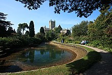
Wells, Somerset map & travel guide with history & landmarks to explore
Visit Wells, Somerset Walkfo Stats
With 41 travel places to explore on our Wells, Somerset travel map, Walkfo is a personalised tour guide to tell you about the places in Wells, Somerset as you travel by foot, bike, car or bus. No need for a physical travel guide book or distractions by phone screens, as our geo-cached travel content is automatically triggered on our Wells, Somerset map when you get close to a travel location (or for more detailed Wells, Somerset history from Walkfo).
| Travel Location: Travel Area: | Wells, Somerset [zonearea] | Audio spots: Physical plaques: | 41 13 | Population: | [zonesize] |
|---|
Average seasonal temperatures at zone
Tourist Guide to Wells, Somerset Map
Wells, Somerset map historic spot | Wells, Somerset map tourist destination | Wells, Somerset map plaque | Wells, Somerset map geographic feature |
| Walkfo Wells, Somerset travel map key: visit National Trust sites, Blue Plaques, English Heritage locations & top travel destinations in Wells, Somerset | |||