Travel to Tonbridge Map
Tonbridge tourist guide map of landmarks & destinations by Walkfo
 Explore
20
travel
spots
 When travelling to Tonbridge, Walkfo’s has created a travel guide & Tonbridge overview of Tonbridge’s hotels & accommodation, Tonbridge’s weather through the seasons & travel destinations / landmarks in Tonbridge. Experience a unique Tonbridge when you travel with Walkfo as your tour guide to Tonbridge map.
Tonbridge history
The town was recorded in the Domesday Book 1087 as Tonebrige, which may indicate a bridge belonging to the estate or manor. Another theory suggests that the name is a contraction of “town of bridges”, due to the large number of streams the High Street originally crossed. Until 1870, the town’s name was spelt Tunbridge, as shown on old maps including the 1871 Ordnance Survey map and contemporary issues of the Bradshaw railway guide.
Normans and Tonbridge Castle
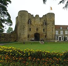
Tonbridge stands on a spur of higher land where the marshy River Medway could be more easily forded. A motte and bailey castle was built here in the 11th century by Richard Fitz Gilbert, son of the murdered guardian of William the Conqueror in his infancy. For much of its existence, the town remained to the north of the river, since the land to the south was subject to extensive seasonal flooding.
Medieval
Tonbridge was taken by King John after the signing of the Magna Carta. The town was besieged by Prince Edward, son of Henry III, who burnt it rather than see it fall. The castle became an official residence and records repository of Edward II. During Queen Mary’s reign the town was involved in an uprising against the Queen’s marriage to Spain.
17th and 18th centuries
In 1740 an Act of Parliament was passed to make the River Medway navigable to Tonbridge by the Medway Navigation Company. During the Civil War the town was garrisoned by the Parliamentarian side who refortified the castle. Later, the town and its surroundings became famous for the production of finely inlaid wooden cabinets, boxes and other objects called Tunbridgeware.
19th century to present

During the March 1880 parliamentary election, Tonbridge was the scene of a riot. During World War II a prisoner of war camp was built at the junction of Tudeley Lane and Pembury Road. Ruth Ellis, the last woman in the United Kingdom to be hanged, was married at the registry office in Tonbridge on 8 November 1950.
Securitas depot robbery
Tonbridge was the location of the largest cash theft in British criminal history. On 22 February 2006, over £53.1 million was stolen from the Securitas cash-handling depot in Vale Road to the east of the High Street. Five people were convicted at the Old Bailey in 2008.
Tonbridge map & travel guide with history & landmarks to explore
Visit Tonbridge Walkfo Stats
With 20 travel places to explore on our Tonbridge travel map, Walkfo is a personalised tour guide to tell you about the places in Tonbridge as you travel by foot, bike, car or bus. No need for a physical travel guide book or distractions by phone screens, as our geo-cached travel content is automatically triggered on our Tonbridge map when you get close to a travel location (or for more detailed Tonbridge history from Walkfo).
| Travel Location: Travel Area: | Tonbridge [zonearea] | Audio spots: Physical plaques: | 20 5 | Population: | [zonesize] |
|---|
Average seasonal temperatures at zone
Tourist Guide to Tonbridge Map
Tonbridge map historic spot | Tonbridge map tourist destination | Tonbridge map plaque | Tonbridge map geographic feature |
| Walkfo Tonbridge travel map key: visit National Trust sites, Blue Plaques, English Heritage locations & top travel destinations in Tonbridge | |||