Travel to Rossington Map
Rossington tourist guide map of landmarks & destinations by Walkfo
 Explore
10
travel
spots
 When travelling to Rossington, Walkfo’s has created a travel guide & Rossington overview of Rossington’s hotels & accommodation, Rossington’s weather through the seasons & travel destinations / landmarks in Rossington. Experience a unique Rossington when you travel with Walkfo as your tour guide to Rossington map.
Rossington history
The name Rossington translates from the old Anglo-Saxon name of ‘Farm on the Moor’ Until the reign of Henry VII, the area was in Nottinghamshire. There are remains of both a Roman fort and pottery kilns in the area.
Rossington villages
The area known as “Rossington” is made up of a number of villages and hamlets. Rossington Bridge was once the site of a major Roman fort (the largest between Lincoln and York) Littleworth was enlarged to a great degree in the 1970s, when Littleworth Park Estate was built.
Colliery
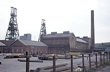
Rossington Main Colliery was sunk between 1912 and 1915. The need for workers in and around the pit led to the building of large numbers of houses near to the pit in what was called New Rossington. The mine closed briefly between 1993 and 1994 before finally closing in 2007.
Rail transport
The ‘Old Village’ and ‘New Village’ are separated by the East Coast Main Line. Rossington railway station was closed for regular services in 1958 but a few special trains stopped there until the late 1960s. The only surviving building is the old station cottages, which stand on the north west side of the crossing and are now private dwellings.
Sport
Rossington Main Football Club was formed in 1919 as Rossington Colliery, originally playing behind the colliery offices in New Rossington, before moving to their current home at the end of Oxford Street in 1921. Rossington is the home to the ‘RASCALS’ swimming team based at Rossington Sports Centre.
Rossington map & travel guide with history & landmarks to explore
Visit Rossington Walkfo Stats
With 10 travel places to explore on our Rossington travel map, Walkfo is a personalised tour guide to tell you about the places in Rossington as you travel by foot, bike, car or bus. No need for a physical travel guide book or distractions by phone screens, as our geo-cached travel content is automatically triggered on our Rossington map when you get close to a travel location (or for more detailed Rossington history from Walkfo).
| Travel Location: Travel Area: | Rossington [zonearea] | Audio spots: Physical plaques: | 10 1 | Population: | [zonesize] |
|---|
Average seasonal temperatures at zone
Tourist Guide to Rossington Map
Rossington map historic spot | Rossington map tourist destination | Rossington map plaque | Rossington map geographic feature |
| Walkfo Rossington travel map key: visit National Trust sites, Blue Plaques, English Heritage locations & top travel destinations in Rossington | |||