Travel to Pontefract Map
Pontefract tourist guide map of landmarks & destinations by Walkfo
 Explore
33
travel
spots
 When travelling to Pontefract, Walkfo’s has created a travel guide & Pontefract overview of Pontefract’s hotels & accommodation, Pontefract’s weather through the seasons & travel destinations / landmarks in Pontefract. Experience a unique Pontefract when you travel with Walkfo as your tour guide to Pontefract map.
Pontefract history
Neolithic
In 2007 a suspected extension of Ferrybridge Henge – a Neolithic henge – was discovered near Pontefract during a survey in preparation for the construction of a row of houses. Once the survey was complete, the construction continued.
Roman
The modern town is situated on an old Roman road (now the A639), described as the “Roman Ridge” This is believed to form part of an alternative route from Doncaster to York via Castleford and Tadcaster.
Anglo-Scandinavian history
The period of Yorkshire’s history between the demise of the Viking king Eric Bloodaxe in 954 and the arrival of the Normans in 1068 is known as the Anglo-Scandinavian age. In Yorkshire, place-name locations often contain the distinctive Danish word ‘-by’ i.e. Kirkby. The modern township of Pontefract consisted of two Anglo-scandinavan settlements, known as Tanshelf and Kirkby, known in the 1086 Domesday Book.
Medieval
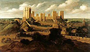
After the Norman conquest in 1066 almost all of Yorkshire came under the ownership of followers of William the Conqueror, one of whom was Ilbert de Lacy who became the owner of Tateshale (Tanshelf) where he began to build a castle. Pontefract Castle began as a wooden motte and bailey castle, built before 1086 and later rebuilt in stone. The de Lacys lived in the castle for more than two centuries and were holders of the castle and the Honour of Pontefract from 1067 until the death of Alice de Lacy in 1348. King Richard II was murdered at the castle in 1400. Little is known of the precise nature of his demise; in particular Shakespeare may have “adjusted” the facts for his own purposes. There are at least three theories which attempt to explain his death: He was starved to death by his keepers, he starved himself to death or he was murdered by Sir Piers (Peter) Exton on 14 February 1399 or 1400. The town of Pontefract and the village of Wentbridge are of central importance to the legend of Robin Hood, as it was told in the Middle Ages. The Fifteenth century Robin Hood ballads place the outlaw’s activities in the forest of Barnsdale, the southern edge of which bordered modern Wakefield. The earliest surviving manuscript of a Robin Hood ballad, “Robin Hood and the Potter” makes reference to Wentbridge: “‘Y mete hem bot at Went breg,’ s(e)yde Lytyll John” (‘I met him but at Wentbridge’, said Little John). Likewise, the Fifteenth Century ballad “A Gest of Robyn Hode”, appears to make a cryptic reference to the village by depicting a friendly knight explaining to Robin that he ‘went at a brydge’ where there was ‘a wraste-lyng’ (wrestling). Significantly, the Gest of Robyn Hode makes a very specific reference to a location within Wentbridge known as ‘the Saylis’ and ‘the Sayles’, as in a four line stanza the outlaw chief instructs his Merry Men to The 19th-century antiquarian Joseph Hunter identified the site of the Saylis: a small tenancy, of one-tenth of a knight’s fee (i.e. a knight’s annual income), located on high ground 500 yards (457.2 metres) to the east of the village of Wentbridge in the manor of Pontefract. The Saylis is recorded as having contributed towards the aid that was granted to King Edward III in 1346–47 for the knighting of his son, the Black Prince. The late, great historians Richard Barrie Dobson and John Taylor indicated that this location provides a very specific clue to Robin Hood’s Pontefract heritage, noting that such evidence of continuity makes it virtually certain that the Saylis or Sayles, which was so well known to the Robin Hood of the “Gest” survived into modern times as the ‘Sayles Plantation’ near Wentbridge. To commemorate this, English Heritage has sited a Blue Plaque on the bridge that stands in the heart of the village, above the River Went, lending weight to Pontefract’s claims to be the true home of Robin Hood. Wentbridge is a small village in the City of Wakefield district of West Yorkshire, England. It lies around 3 miles (5 km) southeast of its nearest town of size, Pontefract, close to the A1 road. During the Middle Ages the village of Wentbridge was itself sometimes referred to by the name of Barnsdale because it was the main settlement in the Forest of Barnsdale. The county boundary follows the A1 from the River Went to Barnsdale Bar, which is the southernmost point of North Yorkshire. Close by to the southwest is the Roman Ridge, a Roman road, known in the Middle Ages as Watling Street, closely follows the course of the modern-day A639. It was at one time, prior to modern construction works being completed, possible to look down from the Saylis upon Watling Street as it snaked through the village of Wentbridge and it is upon this stretch of highway that Robin Hood and his Merry Men are believed to have committed their famous heists. Earlier historians have usually assumed that this district was heavily wooded. However, aerial photography and excavation have shown that the region has always been a largely pastoral landscape dotted with occasional settlements. In close proximity to the village of Wentbridge there are, or were, some notable landmarks which relate to Robin Hood. The earliest-known Robin Hood place-name reference – in Yorkshire or anywhere else – occurs in a deed of 1322 from the two cartularies of Monk Bretton Priory, near the town of Barnsley. The cartulary deed refers in Latin to a landmark named ‘the Stone of Robert Hode’ (Robin Hood’s Stone), which was located in the Barnsdale area. According to J. W. Walker this was on the eastern side of the Great North Road, a mile south of Barnsdale Bar. On the opposite side of the road once stood Robin Hood’s Well, which has since been relocated six miles north-west of Doncaster, on the south-bound side of the Great North Road. Further evidence of Robin Hood’s Wakefield connections comes by way of Michael Drayton’s Poly-Olbion Song 28 (67–70), composed in 1622. The poem strengthens Robin Hood’s connections to Pontefract because it speaks of the outlaw’s death and clearly states that the outlaw died at ‘Kirkby’. Kirkby was an Anglo-Saxon settlement upon which the modern town Pontefract stands. In 2014, the historian Dr S. A. La’ Chance published a thesis that detailed how a notorious medieval outlaw named Swein-Son-Of-Sicga, and styled by contemporaries as ‘The Prince of Thieves’ inhabited the forested areas of Barnsdale, on the outskirts of Pontefract, and made a living by robbing, amongst others Abbot Benedict of Selby. Professor J. Green indicates that Hugh Fitz Baldric, the late eleventh century Sheriff of Nottingham and Yorkshire, held responsibility for bringing Swein-Son-Of-Sicga to justice. Acknowledging this, La’ Chance suggested that the Robin Hood legend is loosely based upon the deeds of Swein-Son-Of-Sicga. La’ Chance closed his thesis by suggesting that, in all likelihood, the outlaw drew his final breath at Saint Nicholas’s hospital, Kirkby (modern day Pontefract), which would account for the reference to Robin Hood’s death in the Poly-Olbion.
Early modern history
In Elizabethan times the castle, and Pontefract itself, was referred to as “Pomfret” In 1648–49 the castle was laid under siege by Oliver Cromwell, who said it was “… one of the strongest inland garrisons in the kingdom” Three sieges by the Parliamentarians left the town “impoverished and depopulated” In March 1649, after the third siege, the town petitioned Parliament for the castle to be slighted.
Pontefract map & travel guide with history & landmarks to explore
Visit Pontefract Walkfo Stats
With 33 travel places to explore on our Pontefract travel map, Walkfo is a personalised tour guide to tell you about the places in Pontefract as you travel by foot, bike, car or bus. No need for a physical travel guide book or distractions by phone screens, as our geo-cached travel content is automatically triggered on our Pontefract map when you get close to a travel location (or for more detailed Pontefract history from Walkfo).
| Travel Location: Travel Area: | Pontefract [zonearea] | Audio spots: Physical plaques: | 33 24 | Population: | [zonesize] |
|---|
Average seasonal temperatures at zone
Tourist Guide to Pontefract Map
Pontefract map historic spot | Pontefract map tourist destination | Pontefract map plaque | Pontefract map geographic feature |
| Walkfo Pontefract travel map key: visit National Trust sites, Blue Plaques, English Heritage locations & top travel destinations in Pontefract | |||