Travel to North Shields Map
North Shields tourist guide map of landmarks & destinations by Walkfo
61
travel
spots
![]() When travelling to North Shields, Walkfo’s has created a travel guide & North Shields overview of North Shields’s hotels & accommodation, North Shields’s weather through the seasons & travel destinations / landmarks in North Shields. Experience a unique North Shields when you travel with Walkfo as your tour guide to North Shields map.
When travelling to North Shields, Walkfo’s has created a travel guide & North Shields overview of North Shields’s hotels & accommodation, North Shields’s weather through the seasons & travel destinations / landmarks in North Shields. Experience a unique North Shields when you travel with Walkfo as your tour guide to North Shields map.
North Shields history
Earliest records
North Shields is first recorded in 1225, when the Prior of Tynemouth, Germanus, decided to create a fishing port to provide fish for the Priory which was situated on the headland at the mouth of the River Tyne. The burgesses of Newcastle upon Tyne were determined to preserve custom rights that they had enjoyed up till then. They successfully petitioned the king in 1290 and managed to suspend trade from North Shields.
Geographic development

The town was originated on a narrow strip of land alongside the river (around the present-day Clive Street) because of the steep bank which hemmed it in. Prosperous businessmen and shipowners occupied the new town whereas working people remained in the lower part of town. The low, riverside part of the town was linked to the newer, higher part by a series of stairs.
Landmarks

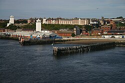
Clifford’s Fort, located on the Fish Quay, was built in the 17th century as a coastal defence against the Dutch. The site of the fort was used to build new fish processing facilities and very little now remains of the original fort. The “Wooden Dolly” statue was used by seafarers as a source of good-luck charms, by cutting pieces of wood from her to be taken with them on voyages.
Industry
In 1887, North Shields was listed as a marine engine, chain cable and anchor manufacturer, shipbuilding yards, roperies, salt-works, and an earthenware and stained glass manufacturer. Smith’s Dock Company was another major employer for many years, eventually closing in 1987.
Culture
In 2009, seating inspired by Plasticine was installed on Bedford Street in the town centre. The seats proved unpopular as their shape prevented rainwater draining off. They were replaced by more traditional metal benches and moved to the Royal Quays Marina in 2011.
Regeneration

In 1992 the Government granted £37.5 million over five years to regenerate an area of the town. An extensive regeneration programme costing £16 million saw the revitalisation of the redundant Albert Edward docks. The Wet N Wild indoor water park, an outlet shopping centre, a bowling alley, a soccer dome and a marina form the centrepiece to the Royal Quays development.
North Shields map & travel guide with history & landmarks to explore
Visit North Shields Walkfo Stats
With 61 travel places to explore on our North Shields travel map, Walkfo is a personalised tour guide to tell you about the places in North Shields as you travel by foot, bike, car or bus. No need for a physical travel guide book or distractions by phone screens, as our geo-cached travel content is automatically triggered on our North Shields map when you get close to a travel location (or for more detailed North Shields history from Walkfo).
| Travel Location: Travel Area: | North Shields [zonearea] | Audio spots: Physical plaques: | 61 33 | Population: | [zonesize] |
|---|
Average seasonal temperatures at zone
Tourist Guide to North Shields Map
North Shields map historic spot | North Shields map tourist destination | North Shields map plaque | North Shields map geographic feature |
| Walkfo North Shields travel map key: visit National Trust sites, Blue Plaques, English Heritage locations & top travel destinations in North Shields | |||