Travel to Ipswich Map
Ipswich tourist guide map of landmarks & destinations by Walkfo
 Explore
124
travel
spots
 When travelling to Ipswich, Walkfo’s has created a travel guide & Ipswich overview of Ipswich’s hotels & accommodation, Ipswich’s weather through the seasons & travel destinations / landmarks in Ipswich. Experience a unique Ipswich when you travel with Walkfo as your tour guide to Ipswich map.
Ipswich history
Ipswich is one of England’s oldest towns, and is claimed to be the oldest still continuing town to have been established and developed by the English. The town has continuous settlement since early Anglo-Saxon times.
Roman settlement
Under the Roman empire, the area around Ipswich formed an important route inland to rural towns and settlements via the rivers Orwell and Gipping . A large Roman fort, part of the coastal defences of Britain, stood at Walton near Felixstowe (13 miles, 21 km) and the largest Roman villa in Suffolk (possibly an administrative complex) stood at Castle Hill (north-west Ipswich).
Middle Ages

The modern town took shape in Anglo-Saxon times (7th–8th centuries) around the Port of Ipswich . As the coastal states of north-western Europe emerged from the collapse of the Roman Empire, North Sea trade and communication between eastern Britain and the continent passed through the former Roman ports of London and York .
Early-modern era

Ipswich was a kontor for the Hanseatic League during the 14th to 17th centuries . During the time of Queen Mary the Ipswich Martyrs were burnt at the stake on the Cornhill for their Protestant beliefs . The town was a major centre for emigration to New England during the 1630s .
19th and 20th centuries
Dr George Birkbeck founded one of the first Mechanics’ Institutes in Ipswich in 1824 . The building, at 15 Tavern Street, has been the site of the library since 1836 .
21st century
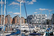
Ipswich has experienced a building boom in the early part of the 21st century . Construction has mainly concentrated around the former industrial dock which is now known as the Ipswich Waterfront . Regeneration to the area has made it a hub of culture in Ipswich .
Ipswich map & travel guide with history & landmarks to explore
Visit Ipswich Walkfo Stats
With 124 travel places to explore on our Ipswich travel map, Walkfo is a personalised tour guide to tell you about the places in Ipswich as you travel by foot, bike, car or bus. No need for a physical travel guide book or distractions by phone screens, as our geo-cached travel content is automatically triggered on our Ipswich map when you get close to a travel location (or for more detailed Ipswich history from Walkfo).
| Travel Location: Travel Area: | Ipswich [zonearea] | Audio spots: Physical plaques: | 124 14 | Population: | [zonesize] |
|---|
Average seasonal temperatures at zone
Tourist Guide to Ipswich Map
Ipswich map historic spot | Ipswich map tourist destination | Ipswich map plaque | Ipswich map geographic feature |
| Walkfo Ipswich travel map key: visit National Trust sites, Blue Plaques, English Heritage locations & top travel destinations in Ipswich | |||