Haslingden tourist guide map of landmarks & destinations by Walkfo
Explore 27 travel spots
When travelling to Haslingden, Walkfo’s has created a travel guide & Haslingden overview of Haslingden’s hotels & accommodation, Haslingden’s weather through the seasons & travel destinations / landmarks in Haslingden. Experience a unique Haslingden when you travel with Walkfo as your tour guide to Haslingden map.
Haslingden history
Thirteen Stones Hill is 2 km (1.2 mi) west of the town and probably dates from about 3000BC. Part of what is now Haslingden, along with the neighbouring towns of Rawtenstall and beyond that Bacup were part of the Forest of Rossendale. The Forest was a hunting park during the late 13th and 14th centuries; ‘Forest’ referred to it being parkland rather than being heavily wooded.
Haslingden map & travel guide with history & landmarks to explore
Visit Haslingden Walkfo Stats
With 27 travel places to explore on our Haslingden travel map, Walkfo is a personalised tour guide to tell you about the places in Haslingden as you travel by foot, bike, car or bus. No need for a physical travel guide book or distractions by phone screens, as our geo-cached travel content is automatically triggered on our Haslingden map when you get close to a travel location (or for more detailed Haslingden history from Walkfo).
Walkfo Haslingden travel map key: visit National Trust sites, Blue Plaques, English Heritage locations & top travel destinations in Haslingden
Famous Haslingden landmarks to explore while you travel at Haslingden
St James’s Church and the ‘Top of the Town’
Haslingden’s Anglican parish church, dedicated to St James the Great, was rebuilt in 1780 on a site occupied by a church building since 1284. St James’s Church now sits well to the north of the town centre, but until the 1930s it was adjacent to the ‘Top of the Town’
Other churches
Manchester Road Methodist Church is a classic building with an Italian-inspired interior. Murray’s Guide also mentions St Thomas, Helmshore (1851); St Stephen, Grane (1867); St John the Baptist, Stonefold (1885); St Peter, Laneside (1893)
The Public Hall
The Public Hall was opened in 1868 and built by a private company formed by ‘gentlemen representing the working classes and temperance movement’ It was bought by the town council in 1898 but by the 1990s it was largely unused except for occasional entertainments. The hall has since been sold by the council to a group representing the Asian heritage community.
Schools
Wesleyan School was the site of the first experiment in the world at a standardised intelligence test. It followed from a suggestion by the industrialist and Liberal politician Sir William Mather in 1900. The test was set by Henry Holman, a schools inspector and educationalist, in 1903.
Library
Michael Davitt migrated to Haslingden with his family in 1840 as a result of the family being evicted from their tenant farm by a British Landlord. He began working in a cotton mill but at the age of 11 his right arm was entangled in a cogwheel and mangled so badly it had to be amputated. He also started night classes at the Mechanics’ Institute and used its library.
Railway
Haslingden was once connected to Accrington and Bury by railway. The East Lancashire Railway built a station here, which remained open to passengers under British Railways until 7 November 1960 and to goods until 2 November 1964. The Bury – Accrington line itself remained in use until December 1966.
Other notable places
The town centre is home to the famous Big Lamp from where all distances in Haslingden are measured. Cissy Green’s Bakery can be found on Deardengate and Holland’s Pies factory. To the northeast there is a 2 kW digital television transmitter.
Beauty spots
There is an extensive area of moorland to the west of Haslingden. The area forms part of the West Pennine Moors. Plans were made in 2007 to build a wind farm consisting of twelve wind turbines on the moors.
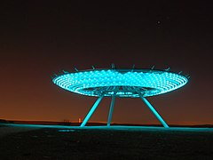
The Halo
The Halo artwork designed by John Kennedy was selected and opened in 2007. It is sited in the hills above Haslingden as the centrepiece of a reclaimed landscape. It glows at night with an impressive viewpoint.
Visit Haslingden’s for a personalised tour guide through Walkfo
There are [audiofact] tourist / travel locations for you to visit using Walkfo. The following example of a Haslingden map spot within our tourist guide app provides a small insight into the type of history & cultural information available for Haslingden specifically through Walkfo’s audio map:
[bestplacedetails] [bestplacecontent]
“Walkfo is a tour guide app to Haslingden with curated content for millions of travel facts and 27 Haslingden travel destinations to explore.”
 Explore
 When travelling to Haslingden, Walkfo’s has created a travel guide & Haslingden overview of Haslingden’s hotels & accommodation, Haslingden’s weather through the seasons & travel destinations / landmarks in Haslingden. Experience a unique Haslingden when you travel with Walkfo as your tour guide to Haslingden map.