Travel to Handbridge Map
Handbridge tourist guide map of landmarks & destinations by Walkfo
 Explore
200
travel
spots
 When travelling to Handbridge, Walkfo’s has created a travel guide & Handbridge overview of Handbridge’s hotels & accommodation, Handbridge’s weather through the seasons & travel destinations / landmarks in Handbridge. Experience a unique Handbridge when you travel with Walkfo as your tour guide to Handbridge map.
Handbridge history
Roman era
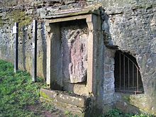
Handbridge is built on a large sandstone outcrop which was used to construct the city walls and buildings. The quarry was also the site of a small shrine to the goddess Minerva which is still visible in what is known as Edgar’s Field.
Post-Roman
By the time of the Domesday Book, the site had grown large enough to be divided into three manors: Overleigh, Netherleigh and Royal Handbridge. Little is known of Handbridge from this time, as Chester was repeatedly attacked by Viking raiders.
Middle Ages

The Welsh name for Handbridge is Treboeth, meaning either “the hot town” or “the burnt town” The current Old Dee Bridge dates from 1353, but at least four other bridges existed on the site beforehand. Chester Weir across the river was built in 1093, under the orders of Hugh Lupus, to provide power to water powered mills along the banks of the river.
English Civil War
During the English Civil War, Chester was one of the last Royalist strongholds, and as such was heavily besieged. Handbridge was burnt once again and the bridge heavily damaged to impede the progress of the Roundhead armies. This forced the Parliamentarians to cross the river at a ford ten miles (16 km) upstream.
Victorian era
Handbridge, Chester, was a poor suburb of the Dee River. The population were primarily industrial workers who worked in the factories that surrounded the area. The Grosvenor Bridge was the largest single-span bridge in the world for 30 years until 1864.
20th century
Handbridge continued to grow in the 20th century with several large schools and a college being built. Among the buildings built were the “Salmon Leap” flats, designed by Gilling Dod and Partners and constructed in 1967/68. On the riverside is a small cottage named “Nowhere”, believed to have originally been a secret tavern.
Handbridge map & travel guide with history & landmarks to explore
Visit Handbridge Walkfo Stats
With 200 travel places to explore on our Handbridge travel map, Walkfo is a personalised tour guide to tell you about the places in Handbridge as you travel by foot, bike, car or bus. No need for a physical travel guide book or distractions by phone screens, as our geo-cached travel content is automatically triggered on our Handbridge map when you get close to a travel location (or for more detailed Handbridge history from Walkfo).
| Travel Location: Travel Area: | Handbridge [zonearea] | Audio spots: Physical plaques: | 200 40 | Population: | [zonesize] |
|---|
Average seasonal temperatures at zone
Tourist Guide to Handbridge Map
Handbridge map historic spot | Handbridge map tourist destination | Handbridge map plaque | Handbridge map geographic feature |
| Walkfo Handbridge travel map key: visit National Trust sites, Blue Plaques, English Heritage locations & top travel destinations in Handbridge | |||