Travel to Epsom Map
Epsom tourist guide map of landmarks & destinations by Walkfo
 Explore
76
travel
spots
 When travelling to Epsom, Walkfo’s has created a travel guide & Epsom overview of Epsom’s hotels & accommodation, Epsom’s weather through the seasons & travel destinations / landmarks in Epsom. Experience a unique Epsom when you travel with Walkfo as your tour guide to Epsom map.
Epsom history
Early history
The earliest evidence of human activity in Epsom is from the mid-Bronze Age . Remains of pits, ditches and post holes in Long Grove Road indicate that the area north of the town centre was used for agriculture in prehistoric times . Pottery sherds and worked flints show that human activity continued into the early Iron Age .
Governance
Epsom was held by Chertsey Abbey from Anglo-Saxon times until the 16th century . The earliest surviving charter confirming the ownership of the town is from 967 . The settlement is thought to have been granted to the abbey in 727 .
Epsom spa

By tradition, the discovery of spa water is attributed to Henry Wicker, a farmer who noticed that his cows refused to drink from a slow spring on Epsom Common . In 1603, local physicians had noted that the local water contained “bitter purging salt”
Horse racing
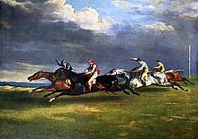
The earliest horse races on Epsom Downs are thought to have been held in the early 17th century . In May 1648, royalist forces were able to assemble on the Downs under the pretence of organising a race . Following the Restoration of the monarchy, Epsom became established as a spa town .
Transport and communications

Stane Street to the west of the modern town centre remained in use through the Anglo-Saxon period . The section of the Roman road to the south of Epsom is thought to have been blocked by the enclosure of Woodcote Park in the 12th century . Visitors to the spa were able to reach Epsom by carriage during the 17th century, although the turnpikes to London and Horsham were not constructed until 1755 .
Residential development
Epsom is unusual among Surrey towns, in that it underwent considerable expansion during the early modern period . As the spa developed in the 1670s, merchants from London started to construct their own mansions on the outskirts of the town .
Commerce and industry
From much of its early history, Epsom was primarily an agricultural settlement . The two common fields attached to the medieval manor, Woodcote (350 acres (140 ha) and Smith Hatch (500 acres (200 ha) were divided into strips . In the 15th century, sheep farming became increasingly important and a wool fair was held in June each year until the 1870s .
Epsom in the world wars

Two battalions of the University and Public Schools Brigade of the Royal Fusiliers were billeted in the town . Some of the racecourse buildings were converted to become a war hospital . 20,000 soldiers were assembled on the Downs for an inspection by Lord Kitchener .
Epsom map & travel guide with history & landmarks to explore
Visit Epsom Walkfo Stats
With 76 travel places to explore on our Epsom travel map, Walkfo is a personalised tour guide to tell you about the places in Epsom as you travel by foot, bike, car or bus. No need for a physical travel guide book or distractions by phone screens, as our geo-cached travel content is automatically triggered on our Epsom map when you get close to a travel location (or for more detailed Epsom history from Walkfo).
| Travel Location: Travel Area: | Epsom [zonearea] | Audio spots: Physical plaques: | 76 5 | Population: | [zonesize] |
|---|
Average seasonal temperatures at zone
Tourist Guide to Epsom Map
Epsom map historic spot | Epsom map tourist destination | Epsom map plaque | Epsom map geographic feature |
| Walkfo Epsom travel map key: visit National Trust sites, Blue Plaques, English Heritage locations & top travel destinations in Epsom | |||