Travel to Dagenham Map
Dagenham tourist guide map of landmarks & destinations by Walkfo
77
travel
spots
![]() When travelling to Dagenham, Walkfo’s has created a travel guide & Dagenham overview of Dagenham’s hotels & accommodation, Dagenham’s weather through the seasons & travel destinations / landmarks in Dagenham. Experience a unique Dagenham when you travel with Walkfo as your tour guide to Dagenham map.
When travelling to Dagenham, Walkfo’s has created a travel guide & Dagenham overview of Dagenham’s hotels & accommodation, Dagenham’s weather through the seasons & travel destinations / landmarks in Dagenham. Experience a unique Dagenham when you travel with Walkfo as your tour guide to Dagenham map.
Dagenham history
Toponymy
Dagenham first appeared in a document (as Dæccanhaam) in a charter of Barking Abbey dating from 666 AD. The name almost certainly originated with a small farmstead, the “ham” or farm of a man called Daecca.
Manor of Barking
The parish of Dagenham was formed in the medieval period to serve the people of Barking, which was owned by the Nunnery of the Barking Abbey. The area held by the manors declined over time, but the parish boundaries remained constant.
Pre-urban landscape
Dagenham was laid out on a N-S axis to give it a share of the marshes by the river, the agricultural land in the centre and the woods and commons on the poorer soils on the high ground in the north. It included a significant part of the now mostly lost Hainault Forest.
Dagenham Breach
South of Dagenham was a low-lying area subject to periodic flooding from the Thames. Dutch engineers built defences and a flood gate on the Beam River being built in the 17th century. In 1707 an exceptionally high tide swept away fourteen feet of embankment and flooded over 1,000 acres of land. A further flood occurred in 1718 after which, under an act of parliament, over £40,000 of public money was spent on successfully closing the breach. The closure of the gap left behind a large lake, also known as “Dagenham Breach”
Whitebait Dinners
Dagenham was formerly home to the famous annual whitebait feast. The custom appears to have been started by the King’s Commissioner of Works to celebrate the breach in the seawall around 1714–20.
Economic development

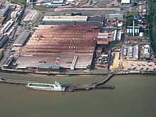
Ford Motor Company moved to Dagenham from Manchester in 1931. It was already the location of supplier Briggs Motorway Bodies. At its peak the plant had 4,000,000 square feet (370,000 m) of floor space. Full production was discontinued in 2002 due to overcapacity in Europe and the difficulty of upgrading the 60-year-old site.
Market gardens to suburban estate

In 1205 Dagenham was large enough to have a chaplain, and the Parish Church of St Peter and St Paul was probably built at around that time. In 1854, the London, Tilbury and Southend Railway was built through the south of the village, near the River Thames. In the 1920s, building of the Becontree estate by the London County Council began in the early 1920s. In 1932 the electrified District line of the London Underground was extended to Upminster through the village.
Dagenham map & travel guide with history & landmarks to explore
Visit Dagenham Walkfo Stats
With 77 travel places to explore on our Dagenham travel map, Walkfo is a personalised tour guide to tell you about the places in Dagenham as you travel by foot, bike, car or bus. No need for a physical travel guide book or distractions by phone screens, as our geo-cached travel content is automatically triggered on our Dagenham map when you get close to a travel location (or for more detailed Dagenham history from Walkfo).
| Travel Location: Travel Area: | Dagenham [zonearea] | Audio spots: Physical plaques: | 77 5 | Population: | [zonesize] |
|---|
Average seasonal temperatures at zone
Tourist Guide to Dagenham Map
Dagenham map historic spot | Dagenham map tourist destination | Dagenham map plaque | Dagenham map geographic feature |
| Walkfo Dagenham travel map key: visit National Trust sites, Blue Plaques, English Heritage locations & top travel destinations in Dagenham | |||