Travel to Chorley Map
Chorley tourist guide map of landmarks & destinations by Walkfo
 Explore
42
travel
spots
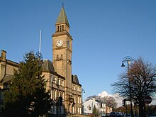
 When travelling to Chorley, Walkfo’s has created a travel guide & Chorley overview of Chorley’s hotels & accommodation, Chorley’s weather through the seasons & travel destinations / landmarks in Chorley. Experience a unique Chorley when you travel with Walkfo as your tour guide to Chorley map.
Chorley history
Toponymy
The name Chorley comes from two Anglo-Saxon words, ċeorl and lēah, probably meaning “the peasants’ clearing” Ley is a common element of place-name, meaning a clearing in a woodland.
Prehistory
There was no known occupation in Chorley until the Middle Ages. The area around the town has been inhabited since at least the Bronze Age. A pottery burial urn from this period was discovered in 1963 on land next to Astley Hall Farm.
Roman period
During the Roman era a Roman road ran near Chorley between Wigan and Walton-le-Dale. Hoards dating from the Roman period have also been found at nearby sites.
Medieval period
Chorley was not listed in the Domesday Book of 1086, though it is thought to be one of the twelve berewicks in the Leyland Hundred. It first appears in historical records in the mid thirteenth century as part of the Croston Lordship acquired by William de Ferrers, Earl of Derby, around 1250. The Earl established a small borough as a two-row settlement along what later became Market Street. It is most likely that the borough was sacked by the Scots during the Great Raid of 1322, which led to the construction of a Peel tower.
19th century to present
Chorley was a vital cotton town with many mills littering the skyline up to the late twentieth century. Most mills were demolished between the 1950s and 2000s with those remaining converted for modern business purposes. The last mill to stop producing textiles was Lawrence’s in 2009.
Chorley map & travel guide with history & landmarks to explore
Visit Chorley Walkfo Stats
With 42 travel places to explore on our Chorley travel map, Walkfo is a personalised tour guide to tell you about the places in Chorley as you travel by foot, bike, car or bus. No need for a physical travel guide book or distractions by phone screens, as our geo-cached travel content is automatically triggered on our Chorley map when you get close to a travel location (or for more detailed Chorley history from Walkfo).
| Travel Location: Travel Area: | Chorley [zonearea] | Audio spots: Physical plaques: | 42 0 | Population: | [zonesize] |
|---|
Average seasonal temperatures at zone
Tourist Guide to Chorley Map
Chorley map historic spot | Chorley map tourist destination | Chorley map plaque | Chorley map geographic feature |
| Walkfo Chorley travel map key: visit National Trust sites, Blue Plaques, English Heritage locations & top travel destinations in Chorley | |||