Travel to Chester Map
Chester tourist guide map of landmarks & destinations by Walkfo
 Explore
200
travel
spots
 When travelling to Chester, Walkfo’s has created a travel guide & Chester overview of Chester’s hotels & accommodation, Chester’s weather through the seasons & travel destinations / landmarks in Chester. Experience a unique Chester when you travel with Walkfo as your tour guide to Chester map.
Chester history
Roman
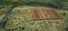
The Roman Legio II Adiutrix during the reign of the Emperor Vespasian founded Chester in AD 79, as a Roman fort with the name Deva Victrix. A civilian settlement grew around the military base, probably originating from trade with the fortress. The fortress was garrisoned by the legion until at least the late 4th century.
Medieval

Deverdoeu was a Welsh name for Chester as late as the 12th century (cf Dyfrdwy, Welsh for the river Dee) Another, attested in the 9th-century History of the Britons, is Cair Legion (“Fort” or “City of the Legion”) This later developed into Caerlleon and then the modern Welsh Caer. In 616, Æthelfrith of Northumbria defeated a Welsh army at the brutal and decisive Battle of Chester.
Early modern period
Chester sided with the royalist cause of King Charles I, but was subdued by Parliamentarians in 1643. The Mayor of Chester, Charles Walley, was removed from office and replaced by William Edwards. Another alderman, Francis Gamull, was ordered to surrender Dee Mills to be demolished.
Industrial history
Chester played a significant part in the Industrial Revolution which began in the North West of England in the latter part of the 18th century. The city village of Newtown, located north east of the city and bounded by the Shropshire Union Canal was at the very heart of this industry. Newtown with its cattle market and canal, and Hoole with its railways were responsible for providing the vast majority of workers.
Modern era

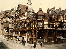
A considerable amount of land in Chester is owned by the Duke of Westminster who owns an estate, Eaton Hall, near the village of Eccleston. Much of Chester’s architecture dates from the Victorian era, many of the buildings being modeled on the Jacobean half-timbered style.
Chester map & travel guide with history & landmarks to explore
Visit Chester Walkfo Stats
With 200 travel places to explore on our Chester travel map, Walkfo is a personalised tour guide to tell you about the places in Chester as you travel by foot, bike, car or bus. No need for a physical travel guide book or distractions by phone screens, as our geo-cached travel content is automatically triggered on our Chester map when you get close to a travel location (or for more detailed Chester history from Walkfo).
| Travel Location: Travel Area: | Chester [zonearea] | Audio spots: Physical plaques: | 200 40 | Population: | [zonesize] |
|---|
Average seasonal temperatures at zone
Tourist Guide to Chester Map
Chester map historic spot | Chester map tourist destination | Chester map plaque | Chester map geographic feature |
| Walkfo Chester travel map key: visit National Trust sites, Blue Plaques, English Heritage locations & top travel destinations in Chester | |||