Travel to Aldermaston Map
Aldermaston tourist guide map of landmarks & destinations by Walkfo
 Explore
48
travel
spots
 When travelling to Aldermaston, Walkfo’s has created a travel guide & Aldermaston overview of Aldermaston’s hotels & accommodation, Aldermaston’s weather through the seasons & travel destinations / landmarks in Aldermaston. Experience a unique Aldermaston when you travel with Walkfo as your tour guide to Aldermaston map.
Aldermaston history
Radiocarbon dating on postholes and pits in the area show activity from 1690 to 1390, 1319 to 1214, and 977 to 899 BCE. Wheat and barley grains have been found in these excavations.
Middle ages
Domesday Book of 1086 identified existence of mill, worth twenty shillings, and two fisheries. Six families have had lordship of the Aldermaston estate since the 11th century. The history of the Lords of the Manor can be traced to Achard, who was born in 1036. The Forsters built a large manor house to the east of the church in 1636.
Victorian era
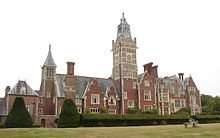
The Congreve Family owned the estate at the time of the 1830 Swing Riots. In 1843, the manor house was destroyed by fire. The estate passed into the Court of Chancery and was purchased by Daniel Higford Davall Burr. Burr held the estate until his death 50 years later, when was inherited by his son, who sold it in 1893.
Post-World War II
RAF Aldermaston was created on the parkland at the southern end of the parish, with XIX Tactical Air Command stationed at the manor house. AEI built the MERLIN reactor on part of the land, which was opened in 1959 by The Duke of Edinburgh. Blue Circle Industries acquired the estate in 1985 and demolished the reactor.
Toponymy
Aldermaston derives its name from Ældremanestone, the Old English for “Ealdorman’s Homestead” The first known Ealdorman of Berkshire fought the Danes with Ethelred of Wessex at the Battle of Englefield in 871.
Aldermaston map & travel guide with history & landmarks to explore
Visit Aldermaston Walkfo Stats
With 48 travel places to explore on our Aldermaston travel map, Walkfo is a personalised tour guide to tell you about the places in Aldermaston as you travel by foot, bike, car or bus. No need for a physical travel guide book or distractions by phone screens, as our geo-cached travel content is automatically triggered on our Aldermaston map when you get close to a travel location (or for more detailed Aldermaston history from Walkfo).
| Travel Location: Travel Area: | Aldermaston [zonearea] | Audio spots: Physical plaques: | 48 0 | Population: | [zonesize] |
|---|
Average seasonal temperatures at zone
Tourist Guide to Aldermaston Map
Aldermaston map historic spot | Aldermaston map tourist destination | Aldermaston map plaque | Aldermaston map geographic feature |
| Walkfo Aldermaston travel map key: visit National Trust sites, Blue Plaques, English Heritage locations & top travel destinations in Aldermaston | |||