Visit Middlesbrough – things to do & explore
 Visit Middlesbrough on a day-trip, weekend away or holiday – and Walkfo becomes your ddd personal digital tour guide to Middlesbrough. Middlesbrough is on the River Tees’s southern bank, west of Redcar and east of Stockton-on-Tees . Until the early 1800s, the area was rural farming land . By 1830, a new town and port had begun to be developed, driven by coal industry and later ironworks . Steel production and ship building began in the late 1800s and remained associated with the town until post-industrial decline occurred in late twentieth century .
Middlesbrough overview by Walkfo
Background for your visit to Middlesbrough?
Middlesbrough history
Early history
Middlesbrough started as a Benedictine priory on the south bank of the River Tees . Its name possibly derived from it being midway between the holy sites of Durham and Whitby . The earliest recorded form of Middlesborough’s name is “Mydilsburgh”
Industrialisation

Iron and steel have dominated the Tees area since 1841 when Henry Bolckow founded the Vulcan iron foundry and rolling mill . Teesside became known as the “Iron-smelting centre of the world” by 1851 . Middlesbrough’s rapid expansion continued throughout the second half of the 19th century (fuelled by the iron and steel industry), the population reaching 90,000 by the dawn of the 20th century .
Welsh migration

A Welsh community was established in Middlesbrough sometime before the 1840s, with mining being the main form of employment . This Welsh population grew rapidly after 1841 when John Vaughan established Teeside’s first ironworks, The Vulcan Works . By 1861 42% of the town’s ironworkers identified as Welsh and one in twenty of the total population .
Irish migration
From 1861 to 1871, the census of England & Wales showed that Middlesbrough consistently had the second highest percentage of Irish born people in England after Liverpool . The Irish population in 1861 accounted for 15.6% of the total population . In 1871 the amount had dropped to 9.2% yet this still placed Middlesborough’s Irish population second in England behind Liverpool .
Second World War
Middlesbrough was the first major British town and industrial target to be bombed during the Second World War . The Luftwaffe first bombed the town on 25 May 1940, when a lone bomber dropped 13 bombs between South Bank Road and the South Steel plant . More bombing occurred throughout the course of the war, with the railway station put out of action in 1942 .
Green Howards
The Green Howards were formed in 1688 to serve King William of Orange, later King William III . As Middlesbrough grew, its population of men came to be most targeted by recruiters . On 6 June 2006, this famous regiment was merged into the new Yorkshire Regiment .
Post Second World War to contemporary era

Middlesbrough’s 1903 Gaumont cinema, originally an opera house until the 1930s, was demolished in 1971 . The Cleveland Centre opened in 1971, Hill Street shopping centre opened in 1981 and Captain Cook Square opened in 1999 . The A66 was built through the town in the 1980s, the Royal Exchange building was demolished, to make way for the road . The original St.Hilda’s area, after decades of decline and clearance, was given a new name of Middlehaven in 1986 on investment proposals to build on the land . Middlehaven is the “Boho” zone, offering office space to the area’s business .
Middlesbrough economy & business
Industry
TeesAMP advanced manufacturing park is designed to accommodate businesses associated with advanced manufacturing and emerging technologies . The area is still home to the nearby large Wilton International industrial site which until 1995 was largely owned by Imperial Chemical Industries .
Port

Teesport is 1 mile (2 km) from the North Sea and 4 miles (6 km) east of Middlesbrough, on the River Tees . It currently handles over 4,350 vessels each year and around 27 million tonnes of cargo . Steel, petrochemical, agribulks, manufacturing, engineering and high street commerce operations all supported through Teesports .
University

Teesside University has 18,000 students, 2,400 staff and operates a £250,000,000 campus in Middlesbrough town-centre . The university has a growing reputation for developing digital businesses particularly in the field of digital animation and for hosting the Animex festival .
Hospitals

The South Tees Hospitals NHS Foundation Trust has the James Cook University Hospital in the town . Roseberry Park Hospital is psychiatric orientated and replaced St Luke’s Hospital . Acklam Road Hospital is operated by Cumbria, Northumberland, Tyne and Wear NHS Trust . Ramsey Health operate the private Tees Valley Hospital in Acklam .
Hospitality and shopping

Middlesbrough has four shopping centres accessible from Linthorpe road: Cleveland Centre, Hill Street, Captain Cook Square and Dundas . Cleveland retail park (South Bank), Parkway Centre (Coulby Newham) and Teesside Park are on the Town’s outskirts .
Former metalworks
In 1900, Bolckow, Vaughan & Co had become the largest producer of steel in Great Britain . In 1914, Dorman Long, another major steel producer from Middlesbrough, became the largest company in Britain, employing over 20,000 . The steel components of the Sydney Harbour Bridge (1932) were engineered and fabricated by the company responsible for the New Tyne Bridge .
Middlesbrough landmarks
Buildings
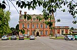
Middlesbrough’s oldest domestic building is Acklam Hall of 1678, built by Sir William Hustler . Town Hall, Town Hall and Empire Empire are Grade II listed buildings . The Dorman Long office is the only commercial building ever designed by Philip Webb .
Artworks

The Temenos sculpture, designed by sculptor Anish Kapoor and designer Cecil Balmond, is a steel structure near to the north west side of the Riverside Stadium . It stands approximately 110 m long and 50 m high and is held together by steel wire . It was unveiled in 2010 at a cost of £2.7 million .
Bridges

The Transporter Bridge spans the River Tees between Middlesbrough and Port Clarence . At 850 feet (260 m) long and 225 feet (69 m) high, it is one of only two left in working order in Britain . The bridge remains in daily use and is Grade II* listed building .
When you visit Middlesbrough
You can visit Middlesbrough and use Walkfo Middlesbrough to discover the best places to walk with our free digital tour guide app created especially for Middlesbrough. Walkfo Middlesbrough has 66 locations with history, culture & travel facts that you explore the same way you would at a museum or art gallery with information audio headset. With Walkfo, you can travel by foot, bike or bus throughout Middlesbrough, being in the moment, without digital distraction or limits to a specific walking route – you choose where you want to go, when you want to go and Walkfo Middlesbrough will keep up. – With numerous tourist walks, tourism locations & travel destinations available in Middlesbrough, our travel AI guide helps you get the best from your visit to Middlesbrough & the surrounding areas. Our explore Middlesbrough app for iPhone & Android delivers hidden history, interesting culture and amazing facts in interactive audio stories in response to where you walk. You exploration Middlesbrough’s National Heritage sites, tourist attractions, historic locations or city streets, with no predefined walk map requirements.
“The Walkfo AI has curated content for millions of locations across the UK, with 66 audio facts unique to Middlesbrough that form an interactive Middlesbrough map for you to explore.”
Walkfo’s visit Middlesbrough map
Best Middlesbrough places to visit
Middlesbrough has many places to explore by foot, bike or bus. Below are a selection of the varied Middlesbrough’s destinations you can visit with additional content available at these Walkfo Middlesbrough’s information audio spots:
 | Acklam, Middlesbrough Acklam is a suburb in the Borough of Middlesbrough, North Yorkshire, England. It is believed that the settlement is Anglo-Saxon in origin, the name is Old English for “place at the oak clearings” or “place of oaks”. At the 2011 census, the Acklam Ward had a population of 6,027 while Kader Ward had a population of 5,074. Brookfield Ward (Trimdon Ward since 2015) had a population of 5,712 while Aryesome Ward had 6,515. The four overall wards had a population of 23,328. |
 | Middlesbrough Theatre Middlesbrough Theatre (formerly the Little Theatre) is a theatre in Middlesbrough, England, which was opened by Sir John Gielgud in 1957 and was one of the first new theatres built in England after the Second World War. |
| Linthorpe Linthorpe is an inner-suburb of Middlesbrough and former village in the Borough of Middlesbrough, North Yorkshire, England. It contains two wards: Linthorpe (containing the cemetery with a population of 9,711) and Park (containing Albert Park with a population of 5,919). The area is near Ayresome, Acklam, Grove Hill and Middlesbrough centre. |
 | Paradise Ground The Paradise Ground was a football ground in Middlesbrough in England. It was the home ground of Middlesbrough Ironopolis. |
 | Middlesbrough Council Middlesbrough Council, formerly known as Middlesbrough Borough Council, is a unitary authority based in Middlesbrough in North Yorkshire, England, but independent of the county council. The authority has combined some duties with its nearby councils to form the Tees Valley Combined Authority. The borough is often considered to be larger than current borough boundaries, with a total built-up population of 174,700. It is in the statistical region of North East England. The council’s borough had a resident population in 2001 of 134,855. A 2006 mid-year estimate suggests the Borough to have a population of 138,400. The borough council unsuccessfully bid to achieve city status in 2012, to celebrate the Queen’s Diamond Jubilee. |
 | Roman Catholic Diocese of Middlesbrough The Roman Catholic Diocese of Middlesbrough is a Latin Rite Roman Catholic diocese based in Middlesbrough, England and is part of the province of Liverpool. It was founded on 20 December 1878, with the splitting of the Diocese of Beverley which had covered all of Yorkshire. The Bishop’s See is in Coulby Newham, Middlesbrough, at St Mary’s Cathedral. |
 | Club Bongo Bongo Club, also known as Club Bongo International, is a reggae club and one of the oldest nightclubs in Middlesbrough, England. The club is located on Bridge Street West near Middlesbrough Railway Station. It closed in June 2017 due to its licence being revoked after a man was attacked at the club. It is due to re-open after a £400,000 refit in spring 2018. |
| Marton, Middlesbrough Marton (officially Marton-in-Cleveland) is a suburb of Middlesbrough, North Yorkshire, England. Until the 1950s, it was a small village next to the hamlet of Tollesby in Yorkshire’s North Riding. The Marton parish originally stretched north to the River Tees, with the expansion of Middlesbrough, the parish became progressively smaller. Attractions include Stewart Park, a large public park given by a former councillor, Dormund Stewart, to people of Middlesbrough in 1928. At the 2011 census, the Marton Ward (Marton East since 2015) had a population of 4,728 while Marton West Ward had a population of 5,305. Ladgate had a population of 5,583 while Beechwood (5,932) and Clairville (5,346) are now the Beechwood and Longlands Ward since May 2015. |
 | Thorntree Thorntree is a housing estate in east Middlesbrough, North Yorkshire, England. The former Thorntree Ward’s population was 6,290, at the 2011 census. Since 2015, the estate shares a ward with Brambles Farm. The housing estate was built in the late 1940s, in the lands of the former Thorntree Farm, after people started to move away from the terraced housing of Middlesbrough town centre and North Ormesby. It has a public park called Thorntree Park. The main roads of the estate are College Road and The Greenway. Thorntree Ward had a population of 5,000 and was identified as the 3rd most deprived (out of 8,414) housing ward in England, in 2000. Since the Index of Multiple Deprivation started measuring smaller output areas with a mean population of 1,500, the three areas of Thorntree later ranked 192nd, 205th and 378th most deprived (out of 34,412) in England respectively. |
| Cleveland, England Cleveland /ˈkliːvlənd/ is a land of hills and dales from the River Tees to Vale of Pickering, England. The area’s name means “cliff-land”. The area corresponds to the former Langaurgh Wapentake. A national park was established in 1952, it covers part of the area and is called the North York Moors. A non-metropolitan county under the same name existed from 1974 to 1996 leading to ambiguity between the county and the name’s historic extent. |
Visit Middlesbrough plaques map

 Middlesbrough has 26 plaques as part of nation or local tourist plaque schemes for you to explore via Walkfo Middlesbrough plaques map when you visit. Plaque schemes such as National Heritage’s “Blue Plaques” provide a visual geo marker to highlight points of interest things, at the places where they happened. Walkfo has researched each plaque to provide additional content when you visit the Middlesbrough plaques whilst using the app. Experience the hidden history & stories behind each location as the Walkfo local tourist guide app uses GPS to trigger audio close to each Middlesbrough plaque. Walkfo also offers millions of additional ‘virtual geo plaques’ that are unique to Walkfo, created across the UK (and the world).
• Customs House, Middlesbrough, George Burlison, and Middlesbrough Exchange Association green plaque • Middlesbrough Winter Garden, Hugh Bell, and Florence Bell blue plaque • John Gilbert Holmes, John Gibson, Cleveland Club, and National Provincial Bank green plaque • Henry Bolckow and John Vaughan blue plaque • William Fallows green plaque • The Admiral, Middlesbrough and Middlesbrough and London Steam Shipping Company green plaque • Amos Hinton green plaque • Tees Transporter Bridge, Middlesbrough and G. C. Imbault red and black plaque • H. G. Reid, North Eastern Daily Gazette, W. H. Blessley, and R. Lofthouse green plaque • Brian Clough green plaque • Philip Webb, Dorman Long, and Bell Bros green plaque • W. H. Blessley green plaque • Cyril Smith green plaque • Jack Hatfield green plaque • Gordon Hoskins, Yorkshire Bank, and K. Backhouse and Company green plaque • Plaque at Acklam Hall • Plaque at Sussex Street • Plaque at Cleveland Buildings • Plaque at former Atlas Garage • Plaque at Snowden Road • Plaque at 8 Exchange Place • Plaque at Commercial Street • Plaque at Cleveland Buildings • Plaque at Forbes’ Buildings • Plaque at Railway Station • Plaque at 21 Stockton Street
When using Walkfo to explore Middlesbrough audio map, you will hear the full story at each of these plaques.
Experience Middlesbrough audio walks & tours
Walkfo is a free app that guides you around things to do / places to visit in Middlesbrough. Explore as you wish, as you would do an art gallery or museum, and when you walk close to any of the 66 locations, our digital tour guide will provide history, culture & travel facts in audio form. With headphone connected, you can explore Middlesbrough freely by foot, bike or bus – with your own personal tour guide in your pocket.
Visiting Middlesbrough with Walkfo’s things to do interactive guide map The “Middlesbrough things-to-do map” below previews the places you can visit in Middlesbrough and surrounding areas with our digital audio tour guide app. Each spot has plaque, building, street or area information on history, culture or tourism.
| Interactive ‘Explore Middlesbrough Map’ This Middlesbrough tourism map shows points of interest within a 4km radius of Middlesbrough centre | Walkfo App Walkfo   |
Walkfo is free to download & use (for a limited time period), so if you are looking to explore Middlesbrough, go to your App Store to search for “Walkfo” or follow a links below and install on your mobile phone. Walkfo is designed for use with headphones or AirPods, so you can walk & explore whilst learning about the things around you without digital distraction.
Apple App Store Google Play StoreThings to do & visit in Middlesbrough and surrounding areas
● Stainsby, North Yorkshire ● Acklam, Middlesbrough ● West Lane ● Whinney Banks ● Linthorpe Cemetery ● Acklam Hall ● Middlesbrough Theatre ● Linthorpe ● Stanley Hollis ● Ayresome Park ● Paradise Ground ● Sacred Heart Church, Middlesbrough ● Dorman Museum ● Maze Park Nature Reserve ● Albert Park, Middlesbrough ● Grove Hill, Middlesbrough ● Marton Grove ● St Clare of Assisi, Middlesbrough ● Swatter’s Carr (Cricket Ground) ● Roseberry Park Hospital ● Middlesbrough Council ● Roman Catholic Diocese of Middlesbrough ● Esk Valley line ● Teesside University ● Easterside ● Saltersgill ● James Cook University Hospital ● Cleveland Centre, Middlesbrough ● St Luke’s Hospital, Middlesbrough ● Middlesbrough meteorite
● Middlesbrough Institute of Modern Art ● Centre North East ● Borough of Middlesbrough ● Middlesbrough Town Hall ● BBC Radio Tees ● Middlesbrough ● Berwick Hills ● Community in a Cube ● Club Bongo ● Pallister ● Riverside Stadium ● Marton, Middlesbrough ● Tees Valley Giants ● Park End, Middlesbrough ● Middlesbrough Priory ● Stewart Park, Middlesbrough ● Brambles Farm ● Netherfields ● Thorntree ● Captain Cook Birthplace Museum ● Teessaurus Park ● Stainton, Middlesbrough ● Gunnergate Hall ● Cleveland, England ● Coulby Newham ● Middlesbrough Cathedral ● Tollesby ● St Bernadette’s, Nunthorpe ● Newham Grange Leisure Farm ● Middlesbrough Rural District ● Hemlington ● Stainton and Thornton ● Thornton, Middlesbrough ● Nunthorpe
Getting to / around Middlesbrough – transport link, station & street map
Getting around in Middlesbrough using public transportation may include roads, streets, trains, undergrounds, buses or trams. Walkfo has the following important Middlesbrough public transport locations with historic / cultural / factual content when you visit:
| Local Middlesbrough Public Transport Stations | Middlesbrough Notable Streets & Road Destinations | |
|---|---|---|
|
|
Paths
A trial e-scooter hire system is operating in Middlesbrough during 2020 . The trial will take place in the city during the summer of 2020 .
Local Middlesbrough historians & Middlesbrough tour guides
 Trying to encourage visitors to Middlesbrough? Whilst Walkfo has millions audio spots already available, Walkfo Creator allows Middlesbrough’s destinations, attractions & landmarks to create their own unique outdoor audio museums & walks using our simple & easy to use Walkfo Creator. – Creating an audio walk is free* and quick (15+ minutes if you prepare text content) with Walkfo Creator doing the hard work of generating AI audio files for geo-spots from the text you provide, with a simply click on a map. – The 100 Amazing Middlesbrough Places is just one example of an outdoor museum created using Walkfo Creator (pictured to the left) for people to safely explore during Covid-19 times whilst visiting a city. The tool is open to tourism organisations, travel destinations & National Trust locations to create their own audio walks to offer free when people visit Middlesbrough destinations. – Walkfo itself is looking to partner with websites offering things-to-do / what’s on events listings to enhance the content of our ‘visit-Middlesbrough’ web pages (for example: www.visitMiddlesbrough.com). If you are interested in partnering, please contact us to discuss options.
* Walkfo Creator is free to use for a limited number of audio spots within a map with a license fee applicable when more than 20 audio spots within location walk are created.